Latitude: 51.293 / 51°17'34"N
Longitude: 0.5394 / 0°32'21"E
OS Eastings: 577149
OS Northings: 157935
OS Grid: TQ771579
Mapcode National: GBR PQV.Z0K
Mapcode Global: VHJM7.9RHN
Plus Code: 9F327GVQ+5P
Entry Name: Old Harbourland
Listing Date: 20 July 1984
Grade: II
Source: Historic England
Source ID: 1086236
English Heritage Legacy ID: 173567
ID on this website: 101086236
Location: Harbourland, Maidstone, Kent, ME14
County: Kent
District: Maidstone
Civil Parish: Boxley
Built-Up Area: Maidstone
Traditional County: Kent
Lieutenancy Area (Ceremonial County): Kent
Tagged with: Building
TQ 75 NE BOXLEY BOXLEY ROAD (east side) Harbourland
5/61 Old Harbourland
G.V. II
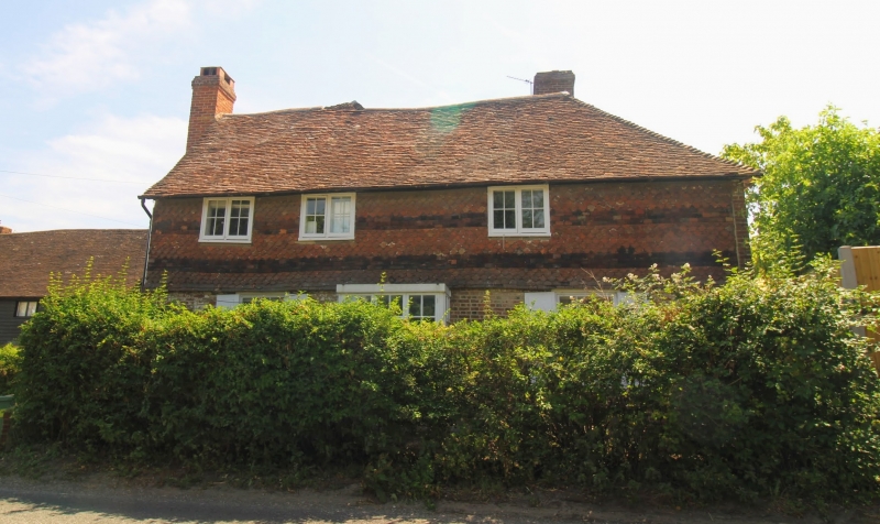
House. Late C16, partly rebuilt in C18, with C19 additions. Timber framed; ground floor brick, first floor tile hung with thick bands of plain and fischscale tiles. Plain tile roof. Late C16 2-bay cross-wing with large C18 bay to right, very narrow C18 addition to left, another large C18 bay to rear of right bay, and large C19 addition filling in the left rear corner. 2 storeys and cellar with brick plinth above a small stone plinth. Roof hipped at right end. Projecting truncated brick stack at left end and ridge stack in rear right wing. Irregular fenestration of 3 two-light casements, 2 towards left end, one to right of centre. Single storey brick lean-to with plain tile roof at left gable end, abutting the stack, with C20 half-door. Interior: has exposed beams and posts.
Listing NGR: TQ7714957935
External links are from the relevant listing authority and, where applicable, Wikidata. Wikidata IDs may be related buildings as well as this specific building. If you want to add or update a link, you will need to do so by editing the Wikidata entry.


Other nearby listed buildings