Latitude: 52.3195 / 52°19'10"N
Longitude: 1.1505 / 1°9'1"E
OS Eastings: 614813
OS Northings: 273716
OS Grid: TM148737
Mapcode National: GBR TJL.HPS
Mapcode Global: VHL9F.WYKR
Plus Code: 9F438592+Q5
Entry Name: Stayer House
Listing Date: 15 June 1951
Last Amended: 12 February 1998
Grade: II*
Source: Historic England
Source ID: 1316595
English Heritage Legacy ID: 468305
ID on this website: 101316595
Location: Eye, Mid Suffolk, IP23
County: Suffolk
District: Mid Suffolk
Civil Parish: Eye
Built-Up Area: Eye (Mid Suffolk)
Traditional County: Suffolk
Lieutenancy Area (Ceremonial County): Suffolk
Church of England Parish: Eye St Peter and St Paul
Church of England Diocese: St.Edmundsbury and Ipswich
Tagged with: House
EYE
TM1473 CASTLE STREET 585-1/7/53 (South side) 15/06/51 No.52 Stayer House (Formerly Listed as: CASTLE STREET (South side) Sayer House)
GV II*
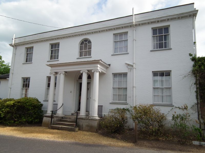
House. Medieval hall house to front extended in late C16 into surviving timber-framed rear range running north-south. Block in south-east angle added c1650. Hall house replaced in mid C18 with brick front range, itself refronted c1820. Single storey banking hall constructed against east return early C19. (Whitewashed brick laid in Flemish bond to front, timber-frame to rear). Red and black-glazed pantiled roof to front range, plaintiles to rear wing. EXTERIOR: facade of 2 storeys. 5-window range. 6-panelled central door with Y-traceried fanlight. Projecting porch on two pairs of Ionic columns supporting plain entablature. Two 6/6 unhorned sashes right and left. First floor with five 3/6 unhorned sashes, the centre window with an arched head. Double modillion eaves cornice below plain parapet partly concealing twin hipped roofs. 2 stacks in centre valley. Banking hall under hipped slate roof: tall 3-light casement with glazing bars to north, doorway in east return. Rear wing of 2 storeys. West side is a 7-window range. Exposed studwork. Fenestration of 2-light and 3-light leaded casements, most with hood moulds. 2 eastern framing bays converted to external loggia. Gabled roof with internal gable-end stack to north. South gable wall of brick, against which is a single-storey lean-to. East face of this wing has a brick ground floor. INTERIOR: between rear wing and front block remains arched exterior door of former hall house. Front block. North room with bolection-moulded fireplace and 6-panelled doors. Rear room with marble fireplace with Ionic columns, re-sited mid C20. Closed-string early C19 staircase with stick balusters and ramped handrail. Rear first-floor east room with domed ceiling plastered over flat in late C20. C17 south-east block in angle with two principal ranges has a sunk-quadrant moulded bridging beam. Former banking hall converted to kitchen during World War II. Rear wing. Ground floor opened into one large room. Frame with chamfered principal posts with splayed tops supporting chamfered bridging beams. Wide fireplace with plain
bressumer. Clasped purlin roof.
Listing NGR: TM1481373716
External links are from the relevant listing authority and, where applicable, Wikidata. Wikidata IDs may be related buildings as well as this specific building. If you want to add or update a link, you will need to do so by editing the Wikidata entry.


Other nearby listed buildings