Latitude: 53.076 / 53°4'33"N
Longitude: -0.9695 / 0°58'10"W
OS Eastings: 469133
OS Northings: 353688
OS Grid: SK691536
Mapcode National: GBR BK3.1QT
Mapcode Global: WHFHF.2YL8
Plus Code: 9C5X32GJ+95
Entry Name: Sunnyside
Listing Date: 20 July 1971
Last Amended: 20 May 1992
Grade: II
Source: Historic England
Source ID: 1288369
English Heritage Legacy ID: 242522
ID on this website: 101288369
Location: Westhorpe, Newark and Sherwood, Nottinghamshire, NG25
County: Nottinghamshire
District: Newark and Sherwood
Civil Parish: Southwell
Built-Up Area: Southwell
Traditional County: Nottinghamshire
Lieutenancy Area (Ceremonial County): Nottinghamshire
Church of England Parish: Southwell Holy Trinity
Church of England Diocese: Southwell and Nottingham
Tagged with: Building
SOUTHWELL
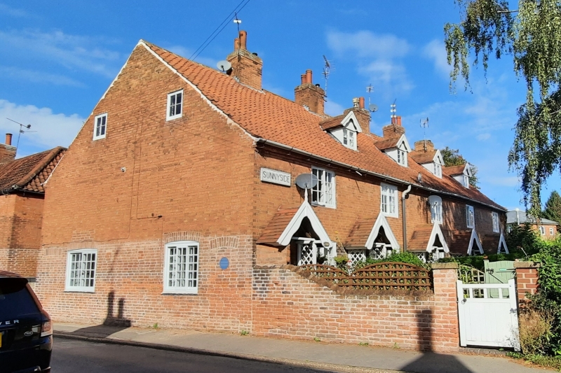
WESTHORPE, Westhorpe SK6953 1919-0/10/241 (North side) 20/07/71 Sunnyside (Formerly Listed as: WESTHORPE Nos.4-8 (Consecutive))
GV II
Terrace of 5 cottages, now 4 dwellings. Early C19, with mid C19 alterations. 3 cottages at the right end demolished c1970. Brick with steep pitched pantile roofs. Cogged eaves, 4 ridge and single gable stacks. Windows are mainly Yorkshire sashes. Ground floor openings have segmental heads. 2 storeys plus attics; 5 window range. Blind backs. Front has 5 windows and above, 4 gabled dormers with bargeboards. 5 doors, the central one replaced by a C20 casement, all with gabled wooden lattice porches with bargeboards. 5 windows. left gable has a blocked door to left and to right, a 2-light and a 3-light Yorkshire sash. In the gable, 2 small C20 casements.
Listing NGR: SK6913353688
External links are from the relevant listing authority and, where applicable, Wikidata. Wikidata IDs may be related buildings as well as this specific building. If you want to add or update a link, you will need to do so by editing the Wikidata entry.


Other nearby listed buildings