Latitude: 54.9113 / 54°54'40"N
Longitude: -1.3978 / 1°23'52"W
OS Eastings: 438702
OS Northings: 557567
OS Grid: NZ387575
Mapcode National: GBR V99.YV
Mapcode Global: WHD55.HTL8
Plus Code: 9C6WWJ62+GV
Entry Name: Former Simpson Street Secondary School
Listing Date: 17 October 1994
Grade: II
Source: Historic England
Source ID: 1279880
English Heritage Legacy ID: 391643
ID on this website: 101279880
Location: Ayre's Quay, Sunderland, Tyne and Wear, SR4
County: Sunderland
Electoral Ward/Division: Millfield
Parish: Non Civil Parish
Built-Up Area: Sunderland
Traditional County: Durham
Lieutenancy Area (Ceremonial County): Tyne and Wear
Church of England Parish: Millfield St Mark
Church of England Diocese: Durham
Tagged with: School building
SUNDERLAND
NZ3857 WELLINGTON LANE 920-1/10/234 (North West side) Former Simpson Street Secondary School
GV II
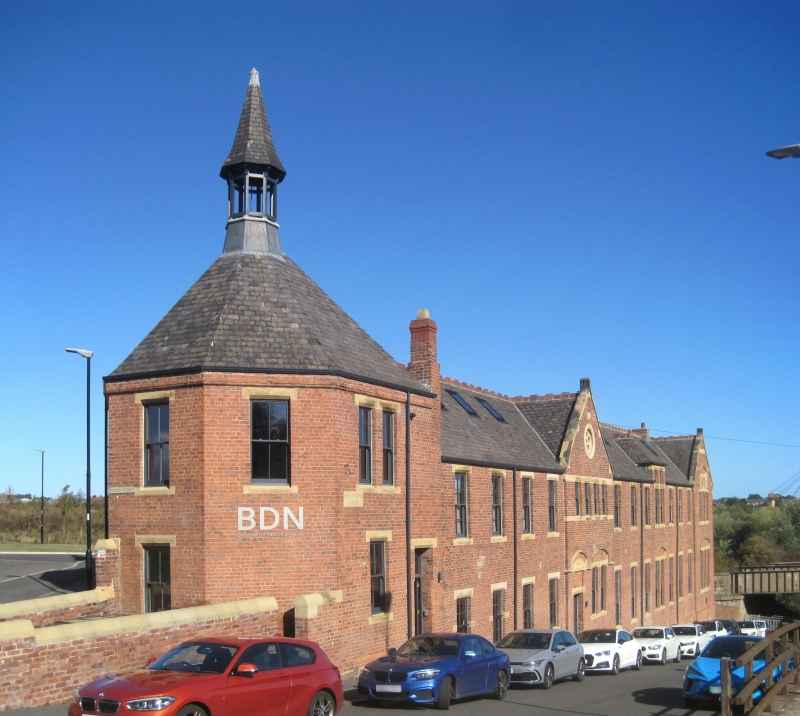
Formerly known as: Simpson Street School WELLINGTON STREET. Secondary school, now workshops. 1883. Possibly by GA Middlemiss. Brick with ashlar dressings; Welsh slate roof with terracotta ridge cresting and stone gable coping. Long range with left tower on rising ground; some Gothic detail. EXTERIOR: 2 storeys, 3:4:4:8:3 windows. Left end a canted return to Simpson Street in a slightly projecting polygonal tower; near-central and right end groups project slightly under gables. Step up to plain door and overlight recessed under flat stone lintel at right of tower; plain double doors under flat stone lintels with blind panel above at left of central gabled section and under third window in 8-bay section. Chamfered stone lintels and sills to paired 4-pane sashes on first floor in front plane of left tower and single sash below; near-central gable has raised segment heads in drip string over ground floor windows and left door; similar dripmould over triple windows in right gabled section and over central pair in 8-bay group, with stone-transomed first floor windows directly above breaking through eaves in dormer with hipped roof. 6-foil roundel in central gable peak, raised dripmould over paired overlights to group of 3 first-floor windows in right gable peak. Left tower has octagonal hipped roof with swept eaves to spirelet on open belfry; chimney at right front rising through eaves. (Corfe T: The Buildings of Sunderland 1814-1914: Newcastle: 1983-: 27).
Listing NGR: NZ3870257566
External links are from the relevant listing authority and, where applicable, Wikidata. Wikidata IDs may be related buildings as well as this specific building. If you want to add or update a link, you will need to do so by editing the Wikidata entry.


Other nearby listed buildings