Latitude: 51.8603 / 51°51'37"N
Longitude: -2.2571 / 2°15'25"W
OS Eastings: 382389
OS Northings: 218004
OS Grid: SO823180
Mapcode National: GBR 1L5.667
Mapcode Global: VH94B.THMQ
Plus Code: 9C3VVP6V+45
Entry Name: Llanthony Priory, Range Between Outer and Inner Courts
Listing Date: 23 January 1952
Last Amended: 15 December 1998
Grade: I
Source: Historic England
Source ID: 1271693
English Heritage Legacy ID: 472287
ID on this website: 101271693
Location: High Orchard, Gloucester, Gloucestershire, GL2
County: Gloucestershire
District: Gloucester
Electoral Ward/Division: Westgate
Parish: Non Civil Parish
Built-Up Area: Gloucester
Traditional County: Gloucestershire
Lieutenancy Area (Ceremonial County): Gloucestershire
Church of England Parish: Hempsted with Gloucester, Saint Mary de Lode and Saint Mary de Crypt
Church of England Diocese: Gloucester
Tagged with: Architectural structure
GLOUCESTER
SO8217 LLANTHONY ROAD 844-1/15/156 (East side) 23/01/52 Llanthony Priory, Range between Outer and Inner Courts (Formerly Listed as: HEMPSTED LANE Remains of Llanthony Priory)
GV I
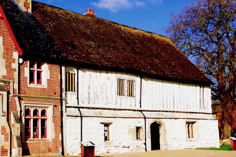
Remains of the range between the Outer and Inner Courts of the Augustinian Priory of Llanthony Secunda. Late C14 and early C16; mullioned windows reset after 1646; C18 and C19 alterations. Squared and coursed limestone, C18 and C19 brick dressings; early C16 timber frame to upper floor; plain tile roof with C18 brick stack off centre to ridge on right. PLAN: formerly a long range of about thirty bays of which six bays in the approximate centre of the range remain to full height; at their southern end the six bays abut the side of the mid C19 farmhouse (qv) built on the site of the continuation of the range to the south and the Inner Gate which gave access to the Inner Court; the northern end of the range is indicated by the remains of its ashlar plinth. EXTERIOR: remaining six bays of two storeys, the lower storey of rubble, the upper storey timber-framed in close studding. East elevation has C20 windows to first floor; timber lintels over 2 windows left of large blocked doorway in chamfered 4-centred architrave; chamfered surround to 3-light C16 window to ground-floor right with hollow-chamfered 4-centred architraves to each light, set in cyma-moulded architrave. West elevation has C20 first-floor windows; one similar 3-light C16 window to ground-floor left, C20 door in inserted (probably C19) opening and later C16 window with chamfered architraves and sunk spandrels. INTERIOR: ground-floor beams of heavy scantling; first floor has signs of former window openings with slots for shutters and collar truss roof with 2 tiers of butt purlins with windbraces, angle side struts to 3 trusses; the disposition of mortice slots indicates that the upper floor was divided into 2 rooms. Probably built as a guest range. In the 1460s it was recorded that 80 people were taking communion in the precincts of the Priory. Scheduled Ancient Monument.
Listing NGR: SO8238918010
External links are from the relevant listing authority and, where applicable, Wikidata. Wikidata IDs may be related buildings as well as this specific building. If you want to add or update a link, you will need to do so by editing the Wikidata entry.


Other nearby listed buildings