Latitude: 53.6975 / 53°41'50"N
Longitude: -1.4132 / 1°24'47"W
OS Eastings: 438843
OS Northings: 422497
OS Grid: SE388224
Mapcode National: GBR LTKP.V9
Mapcode Global: WHDC5.8B99
Plus Code: 9C5WMHWP+XP
Entry Name: Hanson House Farm
Listing Date: 18 February 1965
Grade: II
Source: Historic England
Source ID: 1253748
English Heritage Legacy ID: 437052
ID on this website: 101253748
Location: Normanton, Wakefield, West Yorkshire, WF6
County: Wakefield
Civil Parish: Normanton
Built-Up Area: Normanton
Traditional County: Yorkshire
Lieutenancy Area (Ceremonial County): West Yorkshire
Church of England Parish: Normanton All Saints
Church of England Diocese: Leeds
Tagged with: Agricultural structure
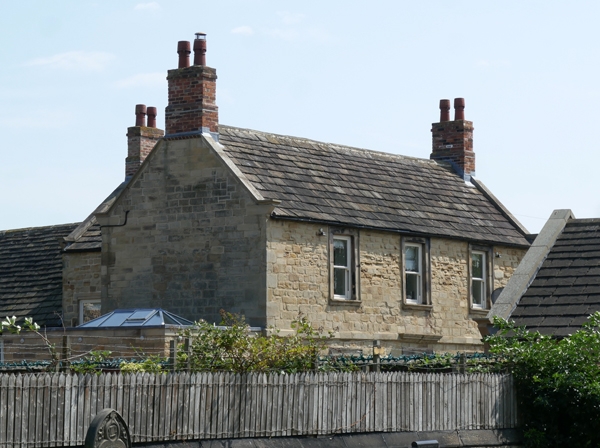
NORMANTON SNYDALE ROAD SE 32 SE (west side, off) 2/56 No. 1 Hanson House Farm and No. 2 Hanson House 18.2.1965 Farm GV II
Farmhouse, now house. Two builds: C16 or earlier, and mid C18; altered. The earlier part of coursed squared sandstone and timber framing, the later of sandstone ashlar and some hand-made brick, with stone slate roof to both. T-plan formed by C18 single-depth front range with a rear wing, with the earlier range continued to the rear of this. C18 element, facing west, of 2- storeys and 3 bays, symmetrical, has 1st floor band, central doorway with fielded-panel door, overlight, simply moulded architrave, and above this a moulded cornice on the band; one window to the left, sashed without glazing bars, and 3 similar windows at 1st floor, all with moulded sills and architraves matching the door, and to the right at ground floor a large French window with matching architrave (but altered glazing); gable copings with kneelers, and gable chimneys. South side of contemporary rear wing, of 2 bays in matching style, a former doorway next to the angle altered as a window, and the other windows all casements (altered): north side has, inter alia, a 2-storey porch in the angle, but is of less interest; and the exposed rear gable wall, of brick with stone quoins, has stone coping with kneelers and a gable chimney. Earlier portion: of 2 lower storeys and 2 bays; the north side, of stone at ground floor, and close-studding at 1st floor, has an inserted doorway near the left end, a buttress to the right of this and 2 altered or inserted windows to the 2nd bay; at 1st floor, which is set back, posts and studs of equal scantling, the studs set in a sill (or rail, if ground floor masonry is cladding to similar framing), a concave brace to the left end of the 1st bay, similar braces at each end of the 2nd bay, and a framed-in window in each bay (differing). Steeply-pitched roof, with chimney stack approx. 1 metre from east gable wall, which is of stone, with raised coping and kneelers. Rear (south side) also of stone, with altered openings. Interior: the earlier range has 2 crass-frames of close-studding, with concave braces from tie-beams to wall posts, that at the junction with the later build with 2 C18 fielded panel doors inserted at 1st floor; beams and joists of large scantling; and a deep chimney stack (fireplace concealed). The C18 build has a fine dog-legged staircase with open string, 2 slender turned balusters per tread, and ramped handrail; and panelling and fielded- panel doors.
Listing NGR: SE3884322497
External links are from the relevant listing authority and, where applicable, Wikidata. Wikidata IDs may be related buildings as well as this specific building. If you want to add or update a link, you will need to do so by editing the Wikidata entry.


Other nearby listed buildings