Latitude: 53.3724 / 53°22'20"N
Longitude: -1.3855 / 1°23'7"W
OS Eastings: 440978
OS Northings: 386352
OS Grid: SK409863
Mapcode National: GBR LYRF.TS
Mapcode Global: WHDDQ.PHFG
Plus Code: 9C5W9JC7+XQ
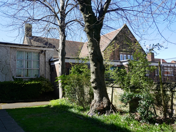
Entry Name: St Joseph's Roman Catholic Primary School and Boundary Wall
Listing Date: 12 December 1995
Grade: II
Source: Historic England
Source ID: 1247189
English Heritage Legacy ID: 456468
ID on this website: 101247189
Location: Handsworth, Sheffield, South Yorkshire, S13
County: Sheffield
Electoral Ward/Division: Woodhouse
Parish: Non Civil Parish
Built-Up Area: Sheffield
Traditional County: Yorkshire
Lieutenancy Area (Ceremonial County): South Yorkshire
Church of England Parish: Handsworth St Mary
Church of England Diocese: Sheffield
Tagged with: Building
SK48NW
784-1/7/842
SHEFFIELD
ST JOSEPH'S ROAD, Handsworth
(North East side)
St Joseph's Roman Catholic Primary School and boundary wall
GV
II
Roman Catholic primary school and adjoining boundary wall.
1879-81. By ME Hadfield & Son. For the 15th Duke of Norfolk.
Mid and late C20 additions and alterations. Coursed squared
stone with ashlar dressings and plain tile roof with
lozenge-shaped stone ridge stack. String course, coped gables,
the right one topped with a gabled single bellcote and cross.
Single storey; 3 window range. L-plan. Three 4-light stone
mullioned glazing bar windows. To right, single bay
flat-roofed addition with coped parapet and a large 4-light
cross casement with label mould. To its right, boundary wall
with chamfered ashlar coping and a pair of square gate piers
with similar caps. Left gable has a 2-light cross casement
with 4 upper lights. INTERIOR not inspected.
Included for group value.
Listing NGR: SK4097886352
External links are from the relevant listing authority and, where applicable, Wikidata. Wikidata IDs may be related buildings as well as this specific building. If you want to add or update a link, you will need to do so by editing the Wikidata entry.


Other nearby listed buildings