Latitude: 51.3635 / 51°21'48"N
Longitude: -2.0305 / 2°1'49"W
OS Eastings: 397975
OS Northings: 162711
OS Grid: ST979627
Mapcode National: GBR 2TS.HGN
Mapcode Global: VHB47.RZFN
Plus Code: 9C3V9X79+9R
Entry Name: Rowde Hall
Listing Date: 3 April 1987
Grade: II
Source: Historic England
Source ID: 1243470
English Heritage Legacy ID: 447219
ID on this website: 101243470
Location: Rowde, Wiltshire, SN10
County: Wiltshire
Civil Parish: Rowde
Built-Up Area: Rowde
Traditional County: Wiltshire
Lieutenancy Area (Ceremonial County): Wiltshire
Tagged with: House
ROWDE HIGH STREET ST 9762 (north side)
11/237 Rowde Hall
II
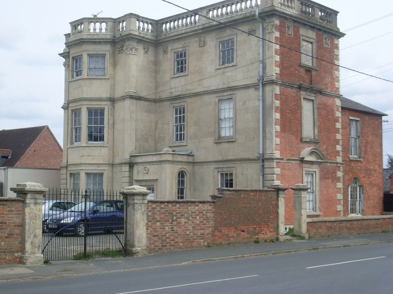
House, now flats, early C18, possibly on earlier core, ashlar- fronted with red brick sides and slate roof. Three storeys, 3- window front with the left bay projecting. Raised plinth, moulded string courses, cornice with egg-and-dart moulding and balustrade. Angles of projecting bay and south-west angle of main range have superimposed order of rusticated ground floor piers, first floor Roman Doric pilasters and second floor pilasters with Baroque capitals (similar to those on No 11 Church Street, Lacock, said to have come from Bowden Park, a demolished house of c1685). Mouldings break forward over angle piers. Under the cornice are a series of deeply-carved square plaques either with radiating foliage motif or crossed plant sprays or a dog's head crest, 2 to left bay, one to return, 3 to right two bays. Left bay has 3- storey canted bay_with mouldings carried around and sashes in architraves, right side has 2-window range of similar sashes but in angle is projecting ashlar enclosed porch with angle pilasters, cornice and parapet, door in architrave with cornice and side-wall round-headed sash. North end wall is Led brick with ashlar dressings, 2-window range of windows with gauged brick heads and keystones, ground floor obscured by C19 or C20 projection. South end, to road, is red brick with ashlar rusticated quoins, mouldings and balustrade carried around and 2 square plaques. One-window range; second-floor blank window in architrave with semi-circular indent in wall below, first-floor blank window with architrave and modillion cornice, breaking string-course, and ground floor 12-pane sash in architrave with segmental pediment, breaking string course. East return is ashlar with mouldings carried around and narrow sashes to upper floors. Mouldings continued around massive projecting ashlar chimney breast, possibly surviving from earlier building. Carved plaques on chimney-breast and on short ashlar stack. To right, early C19 red brick 2-storey addition with slate roof, hipped to right and front ground floor 4:12:4-pane Venetian window with large 12-pane sash above, both with gauged brick heads. Rear range behind not of special interest.
Listing NGR: ST9797562711
External links are from the relevant listing authority and, where applicable, Wikidata. Wikidata IDs may be related buildings as well as this specific building. If you want to add or update a link, you will need to do so by editing the Wikidata entry.


Other nearby listed buildings