Latitude: 52.5153 / 52°30'55"N
Longitude: -1.6438 / 1°38'37"W
OS Eastings: 424271
OS Northings: 290884
OS Grid: SP242908
Mapcode National: GBR 5JB.C73
Mapcode Global: VHBWH.G1CL
Plus Code: 9C4WG984+4F
Entry Name: Stable Block and Adjoining Kennel Approximately 30 Metres South East of Church Farmhouse
Listing Date: 23 March 1988
Grade: II
Source: Historic England
Source ID: 1226139
English Heritage Legacy ID: 423258
ID on this website: 101226139
Location: Church End, North Warwickshire, B46
County: Warwickshire
District: North Warwickshire
Civil Parish: Shustoke
Traditional County: Warwickshire
Lieutenancy Area (Ceremonial County): Warwickshire
Church of England Parish: Whitacres, Lea Marston and Shustoke
Church of England Diocese: Birmingham
Tagged with: Stable
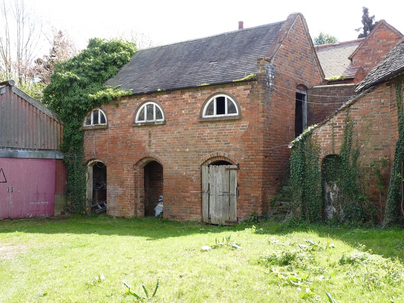
SHUSTOKE SHAWBURY LANE SP2490 (East side) Church End 14/197 Stable block and adjoining kennel approx. 30m SE of Church Farmhouse GV II Stable block. Mid C18. Red brick, Flemish bond. Plain-tiled roof with gable end parapets having moulded brick coping. Plain brick eaves cornice. Two storeys. At first floor, 3 lunette windows with iron glazing bars. 3 ground floor openings in double recessed segmental headed arches. At the north-west end an external staircase to the first floor. Dog kennel under the staircase. Interior: The ground floor has 3 stalls now used for cattle. The fenestration at first floor indicates it was possibly used as a dwelling for agricultural workers. This building is probably one of the model farm buildings built at Church Farm in 1761 (the date shown on the pitch door gable of the stable block south of the house). Interior: 3 separate rooms, possibly for loose boxes, foaling pens or hackney horses.
Listing NGR: SP2427190884
External links are from the relevant listing authority and, where applicable, Wikidata. Wikidata IDs may be related buildings as well as this specific building. If you want to add or update a link, you will need to do so by editing the Wikidata entry.


Other nearby listed buildings