Latitude: 50.4712 / 50°28'16"N
Longitude: -4.7182 / 4°43'5"W
OS Eastings: 207206
OS Northings: 67020
OS Grid: SX072670
Mapcode National: GBR N2.MRVW
Mapcode Global: FRA 170T.7NV
Plus Code: 9C2QF7CJ+FP
Entry Name: 15, Honey Street
Listing Date: 7 January 1994
Grade: II
Source: Historic England
Source ID: 1187701
English Heritage Legacy ID: 368015
ID on this website: 101187701
Location: Bodmin, Cornwall, PL31
County: Cornwall
Civil Parish: Bodmin
Built-Up Area: Bodmin
Traditional County: Cornwall
Lieutenancy Area (Ceremonial County): Cornwall
Church of England Parish: Bodmin
Church of England Diocese: Truro
Tagged with: Building
BODMIN
SX0767 HONEY STREET 629-1/2/73 (North West side) No.15
GV II
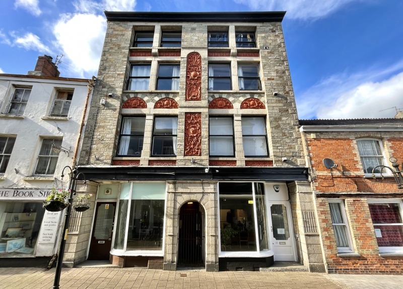
Warehouse with shop. Late C19. Dressed polychrome stone with contrasting granite and Baroque-style red terracotta details; dry slate roof; brick end stacks. Deep rectangular plan. 4 storeys; symmetrical 4-window front. Original 2-pane paired horned sashes. Ground floor has central round-arched granite ashlar doorway with entablature and there are similar end piers; pair of 2-light shop windows with quadrant lights and recessed shop doorways at left and right. Full-width moulded wooden entablature with fascia. First- and 2nd-floor windows are recessed. First floor has panelled aprons and paired terracotta tympana over each pair of windows; central terracotta panel. Taller round-arched terracotta panel to 2nd floor rising between aprons of 3rd-floor windows divided by corbelled mullions. INTERIOR: not inspected. A richly detailed example of its type.
Listing NGR: SX0720367026
External links are from the relevant listing authority and, where applicable, Wikidata. Wikidata IDs may be related buildings as well as this specific building. If you want to add or update a link, you will need to do so by editing the Wikidata entry.


Other nearby listed buildings