Latitude: 52.1085 / 52°6'30"N
Longitude: -1.6221 / 1°37'19"W
OS Eastings: 425980
OS Northings: 245641
OS Grid: SP259456
Mapcode National: GBR 5P6.YHH
Mapcode Global: VHBYF.T8VG
Plus Code: 9C4W495H+95
Entry Name: Halford House
Listing Date: 13 October 1966
Grade: II
Source: Historic England
Source ID: 1024362
English Heritage Legacy ID: 305857
ID on this website: 101024362
Location: Halford, Stratford-on-Avon, Warwickshire, CV36
County: Warwickshire
District: Stratford-on-Avon
Civil Parish: Halford
Built-Up Area: Halford
Traditional County: Warwickshire
Lieutenancy Area (Ceremonial County): Warwickshire
Church of England Parish: Halford
Church of England Diocese: Coventry
Tagged with: House
HALFORD QUEEN'S STREET SP2545 (East side) 6/94 Halford House 13/10/66
GV II
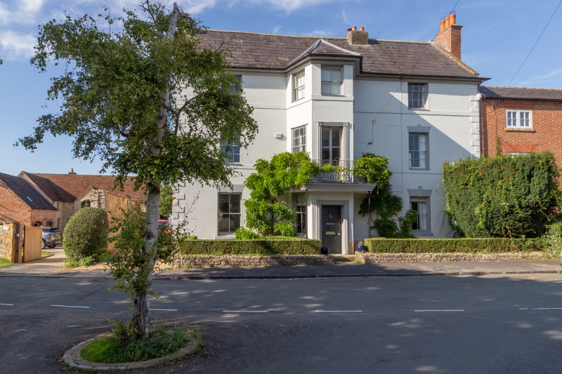
House. Early C19. Stuccoed stone. Brick left end stack and rendered ridge stack. Slate roof. Stone coped gables. Double-depth plan. 3 storeys. 3-window range including central 3-storey bay window with hipped slate roof and containing entrance. Recessed doorway with panelled reveals, moulded wood doorcase with decorated spandrels and 6-panelled door. Ironwork balcony on slender supports. Sash windows throughout mostly with glazing bars and small panes and keyblock heads. Flat bands to first and second floors. Moulded wood cornice. Rusticated qoins. Interior not inspected.
Listing NGR: SP2598045641
External links are from the relevant listing authority and, where applicable, Wikidata. Wikidata IDs may be related buildings as well as this specific building. If you want to add or update a link, you will need to do so by editing the Wikidata entry.


Other nearby listed buildings