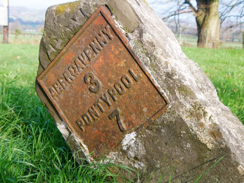
Milestone-Abergavenny 3
A Grade II Listed Building in Llanover, Monmouthshire
Coordinates
Latitude: 51.7779 / 51°46'40"N
Longitude: -3.0062 / 3°0'22"W
OS Eastings: 330679
OS Northings: 209283
OS Grid: SO306092
Mapcode National: GBR F6.Z0YK
Mapcode Global: VH79D.VK3X
Plus Code: 9C3RQXHV+5G
Entry Name: Milestone-Abergavenny 3
Listing Date: 9 December 2005
Grade: II
Source: Cadw
Source ID: 87173
Building Class: Transport
ID on this website: 300087173
Location: On the east side of the A4052 by the junction with the minor road to the parish church and near the North Gate to Llanover Park.
County: Monmouthshire
Town: Abergavenny
Community: Llanover (Llanofer)
Community: Goetre Fawr
Locality: Llanover
Traditional County: Monmouthshire
Tagged with:
Milestone
History
Probably c1821 and contemporary with the dated Llanellen Bridge, all built as part of the turnpiking of what is now A4052, the main road from Abergavenny to Pontypool.
Exterior
Plain standing milestone with ramped top. Inset cast iron plate with relief lettering ABERGAVENNY 3 PONTYPOOL 7.
Reasons for Listing
Included for its special interest as one of a series of early C19 turnpike milestones on the A4052 Abergavenny-Pontypool road.
External Links
External links are from the relevant listing authority and, where applicable, Wikidata.
Wikidata IDs may be related buildings as well as this specific building. If you want to add or update a link, you
will need to do so by editing the Wikidata entry.
Recommended Books
Other nearby listed buildings
-
II
Porth y Pentre
On the east side of the A4052 at the north-western extremity of Llanover Park.
-
II
Ochram Mill
Reached from the main road by a lane to Ochram Farm; on southern boundary of the Community Council area. Set into the bank.
-
II
Court Farm Buildings
To S of Court Farmhouse and Court Farm Cottage, aligned E-W, with block at right angles to W running N towards farmhouse.
-
II
Ty-coch, including attached Granary and Outhouse
About 300m west of the A4052 on the north side of the minor road to Upper Llanover and Blaenavon.
-
II
Barn and attached Stable at Ty-coch
About 30m from the house across the yard.
-
II
Bridge No. 84 Monmouthshire and Brecon Canal
The canal runs parallel to the A4052, separating Llanover village from Upper Llanover. It forms the eastern boundary of the Brecon Beacons National Park. The bridges are numbered from south to north
-
II
Bridge No. 83 Monmouthshire and Brecon Canal
The canal runs parallel to the A4052, separating Llanover village from Upper Llanover. It forms the eastern boundary of the Brecon Beacons National Park. The bridges are numbered from south to north
-
II
Bridge No. 85 Monmouthshire and Brecon Canal
The canal runs parallel to the A4052, separating Llanover village from Upper Llanover. It forms the eastern boundary of the Brecon Beacons National Park. The bridges are numbered from south to north