Latitude: 55.4055 / 55°24'19"N
Longitude: -4.7596 / 4°45'34"W
OS Eastings: 225371
OS Northings: 615865
OS Grid: NS253158
Mapcode National: GBR 44.1GCQ
Mapcode Global: WH2Q0.VDPD
Plus Code: 9C7QC64R+64
Entry Name: Limekiln Dunure
Listing Name: Dunure Limekiln, excluding 12 Castle Road, Dunure
Listing Date: 22 April 2025
Category: C
Source: Historic Scotland
Source ID: 407626
Historic Scotland Designation Reference: LB52632
Building Class: Cultural
ID on this website: 200407626
Location: Maybole
County: South Ayrshire
Electoral Ward: Maybole, North Carrick and Coylton
Parish: Maybole
Traditional County: Ayrshire
Historical development
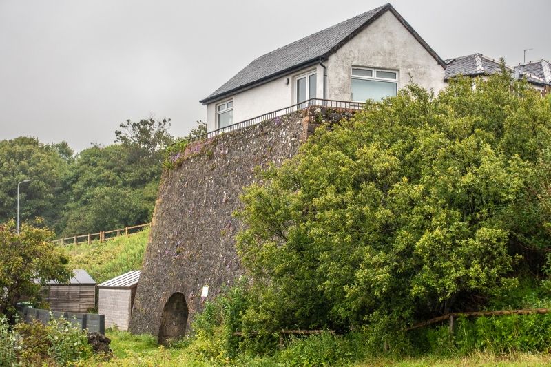
This large kiln with paired single-draw kilns is situated above the harbour at Dunure, with the top at the level of and adjacent to the former coastal road from Ayr to Girvan. The double kiln first appears on the first edition Ordnance Survey Map (surveyed 1856, published 1858) and is also shown on the subsequent 1894 and 1908 maps.
The local Kennedy family estate built Dunure Harbour and its lighthouse in 1832 (Ordnance Survey Name Books). The harbour was built to land coal to serve the estate and wider area but its depth proved unsuccessful for the purpose and the lighthouse was never lit. The limekiln is thought to have been built in the early 19th century by the Kennedy's around the same time, or possibly just before, in order to supply lime for the harbour construction. The kiln is a "draw kiln” type which were typically constructed against the sloping ground, with draw openings on the front face where the lime was collected at the end of the limestone burning process. The scale of the kilns also suggests that they were intended for long term use.
The lush pastures of Ayrshire were ideal for dairy farming however this type of land use removed calcium from the soil and created a subsequent demand for lime for agricultural purposes to help fertilise and counteract the natural acidity of the local soils.
Historical research does not confirm whether the kilns were built to produce lime for use in the harbour construction, lime for agricultural purposes on the estate, or for general commercial lime production. There is little or no evidence to suggest the kilns were in long term use and local knowledge suggests they may never have been lit.
In the earlier 20th century a building was built on top of the kiln and used as a shop. A small gabled section (shown in a Canmore photograph from around 1970) was replaced with the larger pitched roof extension in the later 20th century and the whole building was converted to a dwelling.
Dunure Limekiln meets the criteria for listing for the following reasons:
In accordance with Section 1 (4A) of the Planning (Listed Buildings and Conservation Areas) (Scotland) Act 1997 the following are excluded from the listing: the modern house which sits on top of the limekiln (12 Castle Road, Dunure).
Architectural interest
Design
The limekiln is a good example of a double kiln which retains almost all of its historic fabric including the well-crafted dressed stone segmental arches and the interior details of the draw holes. The design and construction of the kiln is on a substantial, commercial scale with large roughly shaped corner stones and finely sized rubblework to the main walls.
Although there is a later house built on top, the kiln remains in almost completely original condition with only minor brick repairs at the parapet level. The level of surviving fabric is rare when compared with many other disused limekilns in the area and Scotland as a whole, where the majority have suffered significant losses to the fabric after they became redundant.
Setting
The limekiln is large and monolithic in shape and is prominent within its immediate and wider setting. It is intervisible with the harbour which it may have been historically associated. It also forms a strong visual group with the scheduled Dunure Castle and Dovecot (SM6105) which are nearer to the shoreline immediately to its south. The structure sits above many of the houses in the village and overall it makes a very significant contribution to the setting of the 19th century coastal village.
Historic interest
Age and rarity
Limekilns were a very common industrial building type across Scotland in the 18th and 19th centuries where most local areas had at least one to produce lime. Lime was both a crucial component for mortar in construction and as part of the fertilisation and improvement of land for agriculture. The majority of kilns either fell into disrepair or were demolished after construction methods and materials changed in the 19th century and lime was no longer commonly used.
The Dunure limekiln is not associated with any ancillary limeworks structures or is known to have been used in any significant historical event or building project, however it is a well-preserved example of an industrial type of structure that had an important role in the local and regional economic trade in 19th century Scotland.
There are under 30 limekilns in Scotland that are listed in their own right and the majority of those are located in the east of Edinburgh. Those sited on the coast and associated with harbours are rarer and include the later 19th century Ard Neakie kilns (LB516) and Skateraw in East Lothian (LB7707) both of which are listed at Category B and are of a later date than Dunure. Most other known limekilns in Ayrshire are inland and have losses to fabric such that they are not complete to wallhead. Examples of limekilns that survive in their complete form are relatively rare in Scotland and Ayrshire particularly. This example at Dunure, on the coast with associated harbour, has significant historic interest for its building type.


Other nearby listed buildings