Latitude: 55.0755 / 55°4'31"N
Longitude: -1.4669 / 1°28'0"W
OS Eastings: 434136
OS Northings: 575804
OS Grid: NZ341758
Mapcode National: GBR L96R.6C
Mapcode Global: WHD4C.FPQD
Plus Code: 9C7W3GGM+66
Entry Name: The Delaval Arms
Listing Date: 19 May 1950
Last Amended: 15 July 1987
Grade: II
Source: Historic England
Source ID: 1371403
English Heritage Legacy ID: 236065
ID on this website: 101371403
Location: Northumberland, NE26
County: Northumberland
Civil Parish: Seaton Valley
Built-Up Area: Seaton Sluice
Traditional County: Northumberland
Lieutenancy Area (Ceremonial County): Northumberland
Church of England Parish: Delaval Our Lady
Church of England Diocese: Newcastle
Tagged with: Pub
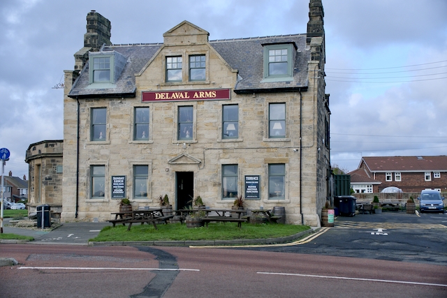
SEATON SLUICE A 193 NZ 37 NW (East side) Hartley 5/101 The Delaval Arms (formerly listed in Whitley Bay UD) 19.5.50 II Inn, mid-C18 with mid-C19 rear wings and early C20 extension. Squared stone with cut dressings; grey slate roof. 2 storeys and attics, 5 narrow bays. Central half-glazed door in shouldered raised stone surround with pediment. Ground floor C20 casements with plate-glass sashes above, all in moulded stone surrounds with slightly-projecting sills. Central pedimented dormer of c.1900 with paired sashes, flanked by flat-topped roof dormers with similar glazing. Stepped-and- banded end stacks. Returns show stepped gables, with raised pedimented centre above band, and small stone-surround windows (c.f. also Lookout Farmhouse, Seaton Delaval). Curved single-storey flat-roofed extension to left.
Rear elevation shows gabled wings flanking earlier stair projection.
Listing NGR: NZ3413675804
External links are from the relevant listing authority and, where applicable, Wikidata. Wikidata IDs may be related buildings as well as this specific building. If you want to add or update a link, you will need to do so by editing the Wikidata entry.


Other nearby listed buildings