Latitude: 51.5881 / 51°35'17"N
Longitude: -1.426 / 1°25'33"W
OS Eastings: 439862
OS Northings: 187855
OS Grid: SU398878
Mapcode National: GBR 6Y6.69T
Mapcode Global: VHC12.7BHW
Plus Code: 9C3WHHQF+7H
Entry Name: Blue Boar Hotel
Listing Date: 3 December 1969
Last Amended: 6 December 1985
Grade: II
Source: Historic England
Source ID: 1368486
English Heritage Legacy ID: 251237
ID on this website: 101368486
Location: Wantage, Vale of White Horse, Oxfordshire, OX12
County: Oxfordshire
District: Vale of White Horse
Civil Parish: Wantage
Built-Up Area: Wantage
Traditional County: Berkshire
Lieutenancy Area (Ceremonial County): Oxfordshire
Tagged with: Hotel
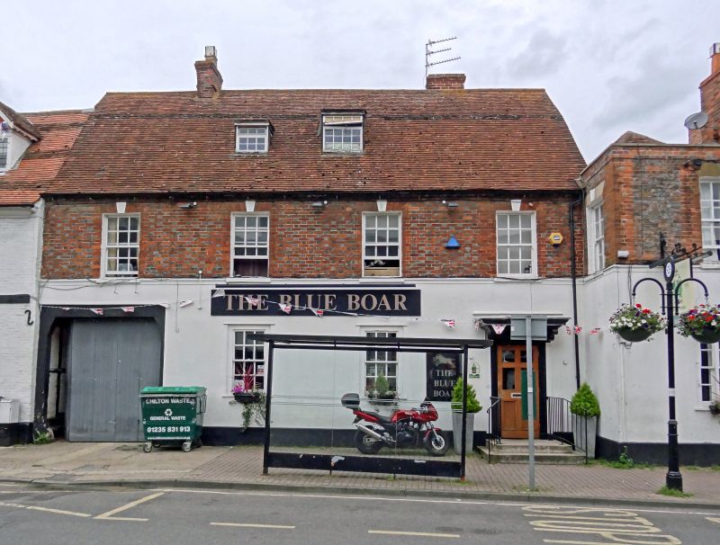
WANTAGE NEWBURY STREET SU3987NE (West side) 9/139 No.4 (Blue Boar Hotel) 03/12/69 (Formerly listed as No.4 Blue Boar Public House)
GV II
House, now inn. c.1740. Rendered ground floor, Flemish bond brick with flared headers to first floor; old and C20 tile roof; red and flared brick stack to left, brick stack. T-plan. 2 storeys and attic; 4-window range. Carved brackets to flat hood over C20 door in moulded architrave to left. Mid C19 six-pane sashes to all windows. Gauged brick flat arches with keystones over first-floor windows. Dentilled eaves. Early C19 sash to roof dormer. Mansard roof; ridge stack to left, rear internal stack. Sashes in similar surrounds to rear. Mid C18 two-storey wing to right of flared brick with red brick quoins and dressings; keyed stone lintels over C18 first-floor sashes; parapet; hipped old tile roof and brick lateral stack. Interior: First and second floors not inspected.
Listing NGR: SU3985487857
External links are from the relevant listing authority and, where applicable, Wikidata. Wikidata IDs may be related buildings as well as this specific building. If you want to add or update a link, you will need to do so by editing the Wikidata entry.


Other nearby listed buildings