Latitude: 51.2052 / 51°12'18"N
Longitude: -2.1901 / 2°11'24"W
OS Eastings: 386817
OS Northings: 145132
OS Grid: ST868451
Mapcode National: GBR 1V5.C49
Mapcode Global: VH97H.0Y1Y
Plus Code: 9C3V6R45+3X
Entry Name: No 22 (The Old Vicarage) Including Boundary Wall to Street
Listing Date: 31 March 1978
Grade: II
Source: Historic England
Source ID: 1364414
English Heritage Legacy ID: 313024
ID on this website: 101364414
Location: Warminster, Wiltshire, BA12
County: Wiltshire
Civil Parish: Warminster
Built-Up Area: Warminster
Traditional County: Wiltshire
Lieutenancy Area (Ceremonial County): Wiltshire
Church of England Parish: Warminster St Denys
Church of England Diocese: Salisbury
Tagged with: Building
WARMINSTER VICARAGE STREET 1. 5411 (North-West Side) No 22 (The Old Vicarage) including boundary wall to street ST 8645 SE 5/295
II GV
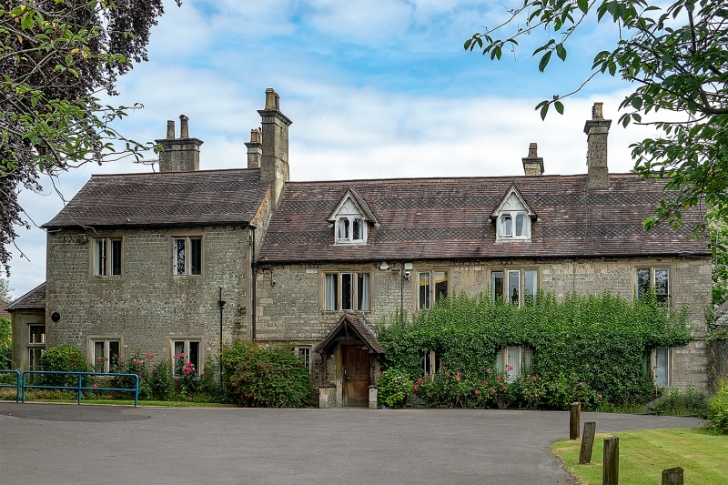
2. A wide fronted house set back from road. The right hand part of the house is early C18, but altered. 2 storeys, lower than the left wing, with attic. Small rubble, tiled roof. (C19 replacement with fishscale bands). Moulded band over ground floor. 3-2-3 two light stone mullion windows (probably Victorian remodelling) the ground floor left hand window offset by later insertion of doorway with C17 type moulded surround, 4 flush panel door and projecting gabled wooden porch. 2 Victorian dormers of 2 lights each. The left hand part is a mid-Victorian extension in similar materials. 2 ranges of 2 light mullion windows (casements) and a later angled bay on left hand return. 5 chimneys in all, 2 on ridge, ashlar with moulded coping. The interior retains several period fittings including an Adam style fireplace in hall; the room to right of hall on entering has a boxed surround to fireplace possibly a pew back removed from church. The house and garden are separated from the road by a wall of coursed rubble some 4 ft high and about 15 yds long with gates.
Listing NGR: ST8681745132
External links are from the relevant listing authority and, where applicable, Wikidata. Wikidata IDs may be related buildings as well as this specific building. If you want to add or update a link, you will need to do so by editing the Wikidata entry.


Other nearby listed buildings