Latitude: 53.9286 / 53°55'42"N
Longitude: -2.9097 / 2°54'34"W
OS Eastings: 340362
OS Northings: 448432
OS Grid: SD403484
Mapcode National: GBR 8R30.VG
Mapcode Global: WH84R.8JN4
Plus Code: 9C5VW3HR+C4
Entry Name: The Old Ship
Listing Date: 17 April 1967
Last Amended: 3 October 1984
Grade: II
Source: Historic England
Source ID: 1361882
English Heritage Legacy ID: 185035
Also known as: The Olde Ship
ID on this website: 101361882
Location: Pilling, Wyre, Lancashire, PR3
County: Lancashire
District: Wyre
Civil Parish: Pilling
Built-Up Area: Pilling
Traditional County: Lancashire
Lieutenancy Area (Ceremonial County): Lancashire
Tagged with: House Restaurant Architectural structure
SD 44 NW PILLING SCHOOL LANE
3/23 The Old Ship (formerly listed as Olde Ship Private Hotel,School Lane) 17.4.1967 - II
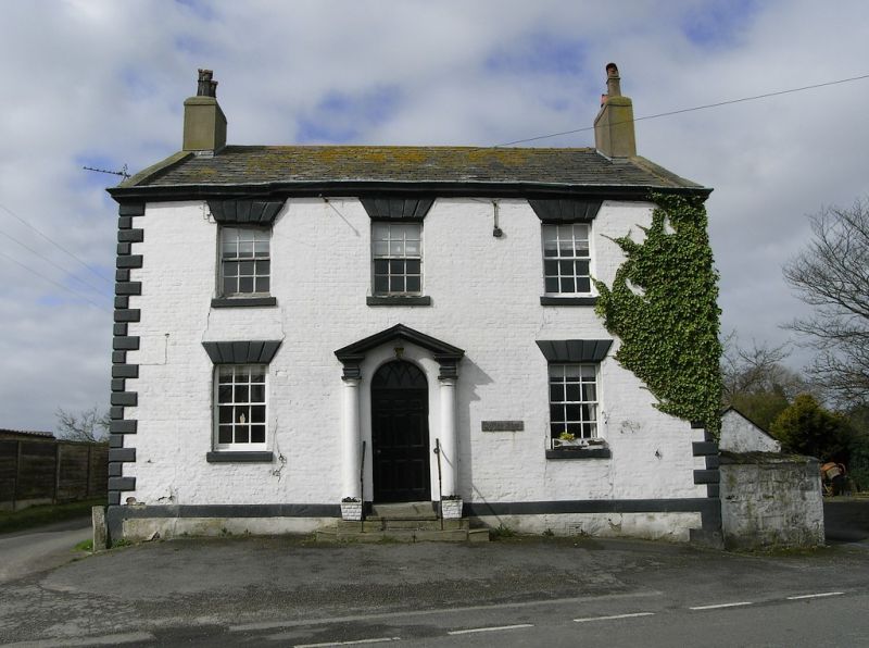
Restaurant, late C18th. Brick with stone dressings, painted, with slate roof. Double-pile plan with end chimneys. A symmetrical composition with chamfered quoins and moulded cornice. 2 storeys, 3 bays. Windows sashed with glazing bars, with plain reveals, stone sills, and lintels with false voussoirs and keystones. The door, of 6 raised panels, has a fanlight with semi-circular head and intersecting glazing bars, and is flanked by attached Tuscan columns supporting an open pediment. Inside there is a dogleg stair with open string, fluted rectangular newels, stick balusters, and a ramped handrail.
Listing NGR: SD4036248432
External links are from the relevant listing authority and, where applicable, Wikidata. Wikidata IDs may be related buildings as well as this specific building. If you want to add or update a link, you will need to do so by editing the Wikidata entry.


Other nearby listed buildings