Latitude: 51.3329 / 51°19'58"N
Longitude: 1.4199 / 1°25'11"E
OS Eastings: 638326
OS Northings: 164862
OS Grid: TR383648
Mapcode National: GBR X0L.CT4
Mapcode Global: VHMCW.KRJL
Plus Code: 9F338CM9+4X
Entry Name: F Hinds
Listing Date: 4 February 1988
Grade: II
Source: Historic England
Source ID: 1356173
English Heritage Legacy ID: 171783
ID on this website: 101356173
Location: Ramsgate, Thanet, Kent, CT11
County: Kent
District: Thanet
Civil Parish: Ramsgate
Built-Up Area: Ramsgate
Traditional County: Kent
Lieutenancy Area (Ceremonial County): Kent
Tagged with: Architectural structure
This list entry was subject to a Minor Enhancement on 14 May 2024 to add historical background, enhance the description, add a new source and to reformat the text to current standards
TR 3864 NW
13/154
(F. Hinds) No. 19/21 HARBOUR STREET (west side) RAMSGATE
GV II
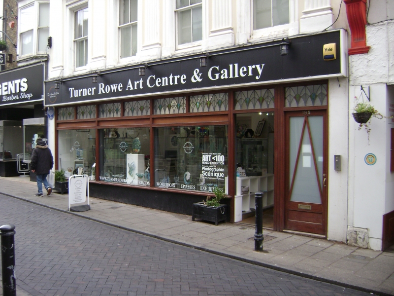
A three-storey house and shop within a terrace, built around 1840.
MATERIALS: rendered with slate roof.
EXTERIOR: three storeys with plat band to first floor supporting five fluted pilasters carrying an entablature to parapet with stack to north. Four sashes to first and second floors, each with vermiculated frieze to cornice. Plate glass ground floor, early C20, canted towards centre, with stained glass upper lights and glazed central door. Large fascia raised to centre.
INTERIOR: not inspected.
Listing NGR: TR3832664862
Ramsgate is situated on the east coast of the Isle of Thanet, facing France and the Low Countries. Originating as a fishing village within the medieval parish of St Laurence, Ramsgate’s development from the C16 was driven by the strategic importance of its coastal port. Ramsgate became associated with the Cinque Ports as a limb of Sandwich from the C14. Late C17 trade with Russia and the Baltic resulted in a wave of investment and rebuilding in the town. In 1749 the construction of a harbour of refuge from storms in the North Sea and Channel was approved, and a cross wall and inner basin were completed in 1779 to the design of John Smeaton. Later improvements included a lighthouse of 1794-1795 by Samuel Wyatt and a clock house of 1817 by Wyatt and George Louch. From the mid-C18 Ramsgate became increasingly popular as a seaside resort, its expansion being accelerated by road improvements and faster sea passage offered by hoys, packets and steamers. During the Napoleonic Wars Ramsgate became a busy garrison town and a major port of embarkation. The arrival of the South Eastern Railway’s branch line in 1846 opened up Ramsgate to mass tourism and popular culture, bringing a range of inexpensive, lively resort facilities. New schools, hospitals and services were also built. The thriving town attracted diverse faith communities; Moses Montefiore founded a synagogue and a religious college at East Cliff Lodge, while AWN Pugin St Augustine’s Church and the Grange as part of an intended Catholic community on the West Cliff. Ramsgate remained a popular holiday destination until the advent of cheap foreign travel in the post-war decades. Falling visitor numbers were exacerbated by the decline of the town’s small trades and industries, fishing and boat-building. However, a ferry and hovercraft port and the large marina created in the inner harbour in the 1970s have continued to bring life to the area.
In the C18 Harbour Street was known as East End and formed one arm of the cruciform arrangement of Ramsgate's four principal streets; the other three were West End (which equates with the High Street), North End (King Street) and South End (Queen Street). The street was largely redeveloped about 1840, Numbers 19 and 21 being one of the better remaining examples of that date.
External links are from the relevant listing authority and, where applicable, Wikidata. Wikidata IDs may be related buildings as well as this specific building. If you want to add or update a link, you will need to do so by editing the Wikidata entry.


Other nearby listed buildings