Latitude: 51.7612 / 51°45'40"N
Longitude: -0.2108 / 0°12'38"W
OS Eastings: 523578
OS Northings: 208460
OS Grid: TL235084
Mapcode National: GBR J9M.FK9
Mapcode Global: VHGPL.9ZFR
Plus Code: 9C3XQQ6Q+FM
Entry Name: The Palace
Listing Date: 6 February 1952
Grade: I
Source: Historic England
Source ID: 1348152
English Heritage Legacy ID: 158407
ID on this website: 101348152
Location: Old Hatfield, Welwyn Hatfield, Hertfordshire, AL9
County: Hertfordshire
District: Welwyn Hatfield
Civil Parish: Hatfield
Built-Up Area: Hatfield
Traditional County: Hertfordshire
Lieutenancy Area (Ceremonial County): Hertfordshire
Church of England Parish: Bishops Hatfield Saint Etheldreda with Saint Luke
Church of England Diocese: St.Albans
Tagged with: Architectural structure
Old Hatfield TL 2308 HATFIELD HATFIELD PARK (west side)
15/144 The Palace
6.2.52
GV I
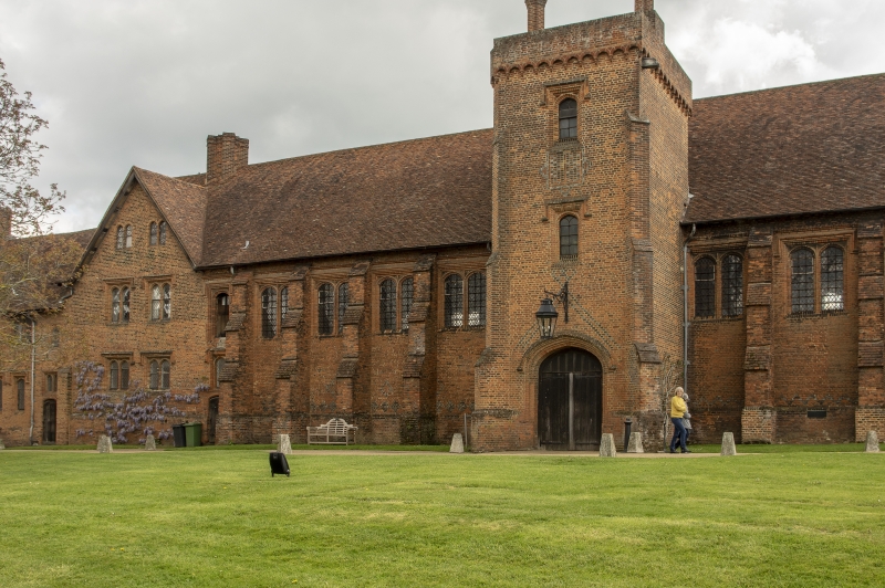
Formerly Palace of the Bishops of Ely, built by John Morton about 1480. Given to Robert Cecil, 1st Earl of Salisbury, in exchange for Theobalds Palace in 1607, and partly demolished, leaving this the east side of a former quadrangular block, and the gate lodge on the west (q.v.). From 1628 until the C20 it was the stables to Hatfield House. Now a hall for entertainments. Red brick with diaper patterning. Much early-mid C19 restoration. 2 storeys and attics. East and west elevations are both 20 windows. 1-window square projecting towers in centre of both sides, rising to apex of plain tile roof. 5 windows each side and 2-window gabled end bays. Mostly 2-light windows under hoodmoulds. C19 stepped buttresses. Towers have ground floor porches with 4-centred arches. Single light casements on 1st and 2nd floors above these. Both towers have burnt-header patterned brick work which is mainly C19 restoration. Parapets on brick corbel tables. N end of range has coach entrance with cambered brick tunnel arch.
Dais of hall was at S end of present all. Kitchens and offices were in the N half of the range. The roof of the hall is a splendid specimen of late medieval timber construction, with principals resting on carved stone corbels, the arched braces moulded, the collar-beams cross-trussed, and with ogee-shaped wind braces in two tiers between the principals. (Pevsner (1977)).
Listing NGR: TL2357808460
External links are from the relevant listing authority and, where applicable, Wikidata. Wikidata IDs may be related buildings as well as this specific building. If you want to add or update a link, you will need to do so by editing the Wikidata entry.


Other nearby listed buildings