Latitude: 51.0109 / 51°0'39"N
Longitude: -3.099 / 3°5'56"W
OS Eastings: 322994
OS Northings: 124074
OS Grid: ST229240
Mapcode National: GBR M1.JNP0
Mapcode Global: FRA 46DF.VWJ
Plus Code: 9C3R2W62+99
Entry Name: Mount Terrace
Listing Date: 4 July 1975
Grade: II
Source: Historic England
Source ID: 1344747
English Heritage Legacy ID: 269813
ID on this website: 101344747
Location: Wilton, Somerset, TA1
County: Somerset
District: Somerset West and Taunton
Electoral Ward/Division: Taunton Manor and Wilton
Parish: Taunton
Built-Up Area: Taunton
Traditional County: Somerset
Lieutenancy Area (Ceremonial County): Somerset
Tagged with: Building
MOUNT STREET 1. 5365 ( North East Side ) Mount Terrace Nos 1 to 8 (consec) ST 2224 SE 11/299 ST 2324 SW 14/299
II GV
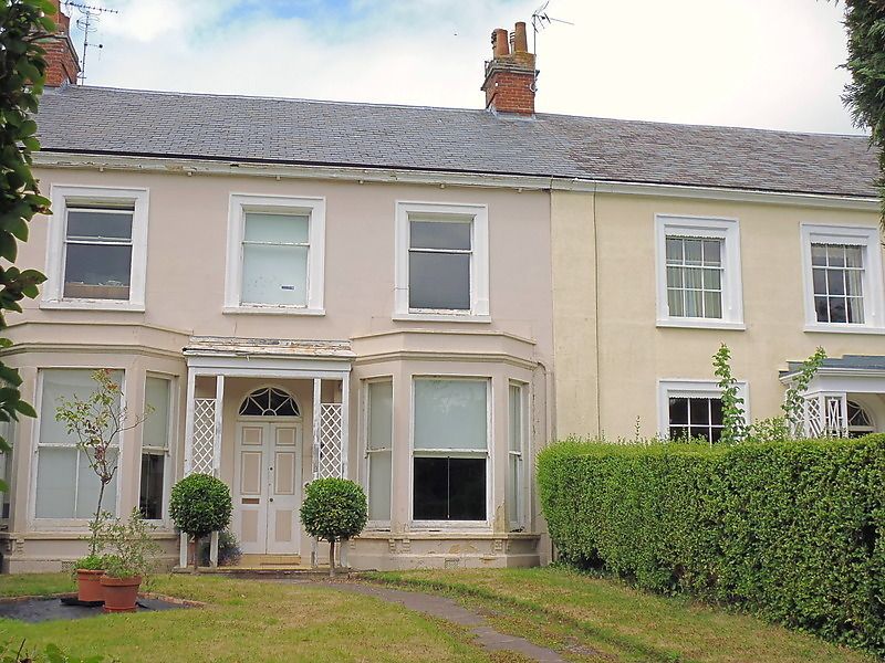
2. Long range of terraced houses at the south end of Mound Street. Probably mid C19, with some alterations. 2 storeys. Stucco fronts. N9 7 isrendered, Continuous slate roof, No 8 with 2 dormers. Moulded eaves cornice. Plain pilasters divide the properties. 3 windows to each with architrave surrounds (missing to No 8). Mostly sashes, some glazing bars. Central round headed doorways with semi-circular traceried fanlights, 6-panel doors. Nos, 1 and 8, small porches attached to ends of the terrace. Nos 2 and 5 to 7 (consec). Canted bays to each side on ground floor, No 7 with crenellated tops. Doorway to No 7 has hood supported by trellis, No 3 Modern pitched tile roof to porch. No 4 Trellised porch over doorway.
All the listed buildings in Mount Street form a group together with the School. Unitarian Chapel, the Lawn and Mary Street House, Mary Street, the listed buildings in Vivary Park, Wilton House in Hammets Walk and Nos 1 to 14 (consec) Upper High Street.
Listing NGR: ST2299424074
External links are from the relevant listing authority and, where applicable, Wikidata. Wikidata IDs may be related buildings as well as this specific building. If you want to add or update a link, you will need to do so by editing the Wikidata entry.


Other nearby listed buildings