Latitude: 51.1388 / 51°8'19"N
Longitude: 0.591 / 0°35'27"E
OS Eastings: 581356
OS Northings: 140912
OS Grid: TQ813409
Mapcode National: GBR QV6.D8J
Mapcode Global: VHJN1.6M9W
Plus Code: 9F324HQR+GC
Entry Name: Well House
Listing Date: 22 June 1989
Grade: II
Source: Historic England
Source ID: 1338680
English Heritage Legacy ID: 169409
ID on this website: 101338680
Location: Frittenden, Tunbridge Wells, Kent, TN17
County: Kent
District: Tunbridge Wells
Civil Parish: Frittenden
Built-Up Area: Frittenden
Traditional County: Kent
Lieutenancy Area (Ceremonial County): Kent
Tagged with: House
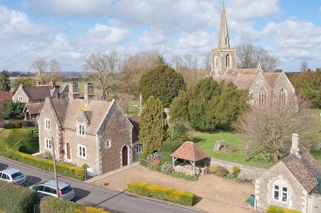
FRITTENDEN THE STREET TQ 8040-8140 (north west side) 14/59 Well House GV II House. Circa 1846-8. probably by R C Hussey. Wealden sandstone with Caen stone dressings and plain tiled roof. T-shaped plan with additional wing. Entrance front: 2 storeys, gabled wing projecting to left, with plinth, quoins and kneelered parapet gables. Gabled half-dormers to right, and stacks to left and to centre. Two 2 light shouldered mullioned windows on each floor, with central boarded door in moulded arched surround. The gabled cross-wing to left is treated identically to rear. Moulded arched doorway with boarded door to right return, with single storey wing to rear right with parapet gable. Catslide to rear with small stack. Part of the complex designed by R C Hussey with the rebuilt church (See B O E Kent I, 290).
Listing NGR: TQ8135640912
External links are from the relevant listing authority and, where applicable, Wikidata. Wikidata IDs may be related buildings as well as this specific building. If you want to add or update a link, you will need to do so by editing the Wikidata entry.


Other nearby listed buildings