Latitude: 51.2405 / 51°14'25"N
Longitude: 0.6783 / 0°40'41"E
OS Eastings: 587046
OS Northings: 152442
OS Grid: TQ870524
Mapcode National: GBR QT4.49P
Mapcode Global: VHJMP.P2YW
Plus Code: 9F326MRH+58
Entry Name: Malthouse
Listing Date: 14 December 1984
Grade: II
Source: Historic England
Source ID: 1336313
English Heritage Legacy ID: 173761
ID on this website: 101336313
Location: Harrietsham, Maidstone, Kent, ME17
County: Kent
District: Maidstone
Civil Parish: Harrietsham
Built-Up Area: Harrietsham
Traditional County: Kent
Lieutenancy Area (Ceremonial County): Kent
Tagged with: Malt house
HARRIETSHAM EAST STREET TQ 85 SE (south west side)
4/28 Malthouse (also known as Bell Farmhouse)
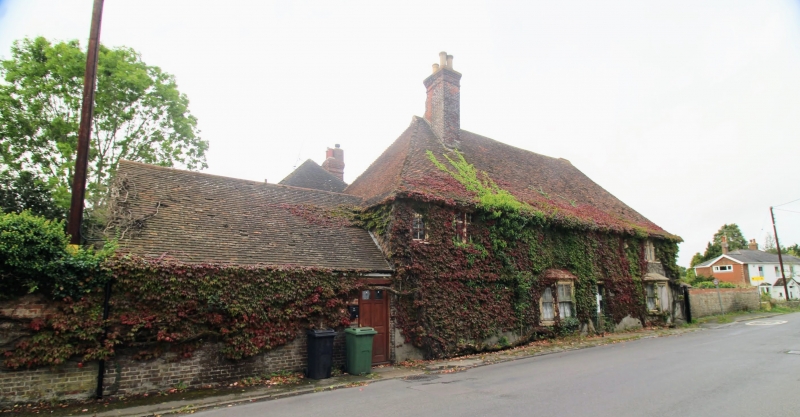
GV II Farmhouse. Mid C16, with early C20 facade. Timber framed. Front elevation cement rendered. Right gable end red brick on ground floor with banded plain and fishscale tiles to first floor. Plain tile roof. 5 timber-framed bays, with continuous jetty to rear and probably originally also to front. 2 storeys on plinth. Projecting eaves with flat soffit. Steeply pitched hipped roof with gablets. Red brick stack in front slope of roof towards left end and another in right hip. Irregular fenestration of 5 early C20 two and three light ovolo-moulded mullioned casements with top lights. 2 ground-floor canted bay windows. Half-glazed and panelled door towards centre, with flat bracketted corniced hood. Additions to rear of 3rd quarter of C19 and 1910. Interior: Plain crown-posts with 2 curved downward and 2 upward braces, one moulded octagonal crown-post at right end. Exposed timbers. Left end of attic formerly held grain bins.
Listing NGR: TQ8709452465
External links are from the relevant listing authority and, where applicable, Wikidata. Wikidata IDs may be related buildings as well as this specific building. If you want to add or update a link, you will need to do so by editing the Wikidata entry.


Other nearby listed buildings