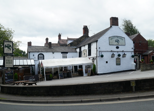
Latitude: 53.3015 / 53°18'5"N
Longitude: -1.473 / 1°28'22"W
OS Eastings: 435216
OS Northings: 378417
OS Grid: SK352784
Mapcode National: GBR LZ48.W6
Mapcode Global: WHDF2.B8ST
Plus Code: 9C5W8G2G+JQ
Entry Name: The Green Dragon Inn
Listing Date: 9 January 1967
Grade: II
Source: Historic England
Source ID: 1335504
English Heritage Legacy ID: 79505
ID on this website: 101335504
Location: Dronfield, North East Derbyshire, S18
County: Derbyshire
District: North East Derbyshire
Civil Parish: Dronfield
Built-Up Area: Dronfield
Traditional County: Derbyshire
Lieutenancy Area (Ceremonial County): Derbyshire
Church of England Parish: Dronfield St John Baptist
Church of England Diocese: Derby
Tagged with: Inn
PARISH OF DRONFIELD CHURCH STREET SK 37 NE 6/25 9.1.67 The Green Dragon Inn GV II Public house. C17, with C18 additions and C19 and C20 alterations. Roughcast sandstone with brick gable stacks, and a Welsh slated roof. L-plan house, with later advanced range at west end. Main range, north elevation, two storeys and attics, two bays with 4-light chamfered windows below windows below dripmoulds flanking the off-centre doorway which has a simply moulded surround. First floor has a 2 and 3-light chamfer mullioned window, both beneath dripmoulds and, on the heads of these openings, 2-light chamfer mullioned attic windows. All openings with leaded lights, some early. Advanced two bay range with sash windows in plain surrounds to the ground floor and above, one semi-circular headed window and one inserted C19 window, both with C20 glazing.
Listing NGR: SK3521678417
External links are from the relevant listing authority and, where applicable, Wikidata. Wikidata IDs may be related buildings as well as this specific building. If you want to add or update a link, you will need to do so by editing the Wikidata entry.


Other nearby listed buildings