Latitude: 50.7263 / 50°43'34"N
Longitude: -2.3467 / 2°20'48"W
OS Eastings: 375623
OS Northings: 91915
OS Grid: SY756919
Mapcode National: GBR 0ZG.7JD
Mapcode Global: FRA 57Z5.1LK
Plus Code: 9C2VPMG3+G8
Entry Name: Ilsington Farm House
Listing Date: 26 January 1956
Grade: II
Source: Historic England
Source ID: 1324050
English Heritage Legacy ID: 106272
ID on this website: 101324050
Location: Ilsington, Dorset, DT2
County: Dorset
Civil Parish: Puddletown
Traditional County: Dorset
Lieutenancy Area (Ceremonial County): Dorset
Church of England Parish: Puddletown with Athelhampton and Burleston St Mary the Virgin
Church of England Diocese: Salisbury
Tagged with: Farmhouse
PUDDLETOWN
SY 79 SE ILSINGTON ROAD
9/84 Ilsington Farm House 26.1.56
- II
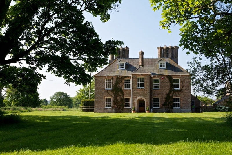
Farmhouse. C17 origin, much altered late C18-early C19. Brick walls in garden wall bond with burnt headers - right end wall plastered. Hipped slate roof with central lead flat; brick dentil cornice at eaves. 2 brick stacks, set laterally, each with 4 shafts set diagonally, with oversailing caps. Similar single shafted stack in centre of front. Double pile plan. 2 storeys and attic. In centre of main elevation a 2-storey hipped roofed porch. Moulded round-arched doorway, with projecting keystone. Part glazed inner door. Above doorway a sash with glazing bars under gauged arch. Each side of porch, ground and first floors each have 2 similar sashes. Attic has 2 hipped dormers with casements with glazing bars. Single storey lean-to at right end. (RCHM Monument 19 Dorset Vol III)
Listing NGR: SY7562391915
External links are from the relevant listing authority and, where applicable, Wikidata. Wikidata IDs may be related buildings as well as this specific building. If you want to add or update a link, you will need to do so by editing the Wikidata entry.


Other nearby listed buildings