Latitude: 51.4539 / 51°27'14"N
Longitude: -0.973 / 0°58'22"W
OS Eastings: 471453
OS Northings: 173271
OS Grid: SU714732
Mapcode National: GBR QLG.J7
Mapcode Global: VHDWT.2QY9
Plus Code: 9C3XF23G+HQ
Entry Name: 7 Gun Street
Listing Date: 14 December 1978
Last Amended: 14 March 2024
Grade: II
Source: Historic England
Source ID: 1321917
English Heritage Legacy ID: 38964
ID on this website: 101321917
Location: Reading, Berkshire, RG1
County: Reading
Electoral Ward/Division: Abbey
Parish: Non Civil Parish
Built-Up Area: Reading
Traditional County: Berkshire
Lieutenancy Area (Ceremonial County): Berkshire
Church of England Parish: Reading St Mary the Virgin
Church of England Diocese: Oxford
Tagged with: Building
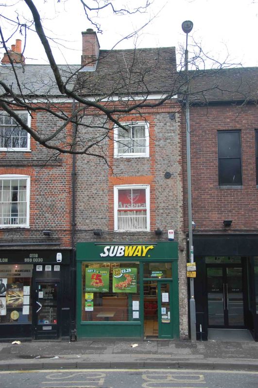
Late-C18 or early-C19 building with C20 rear extension, originally part of a larger house.
Originally part of a larger house of the late C18 or early C19, extended to the rear in the 1950s or 1960s. Commercial use on the ground floor.
MATERIALS: silver grey brick laid in header bond with red brick dressings and a plain tile roof to the northern (front) roof slope. The (later) rear elevation is of red brick laid in stretcher bond.
PLAN: the building has three storeys and is one bay wide. The front roof slope is pitched and to the rear, the roof has been lifted behind the ridge to form a flat roof. The later rear extension is full height, flat-roofed and of roughly equal size to the front range. It runs south from the rear elevation, offset to the east.
EXTERIOR: the ground floor has a C21 shopfront. The first and second floors each have a single timber sash window with two-over-two glazing, the sash boxes set flush to the brickwork. The windows have flat-arches in gauged red brick, and red brick dressings which run the full two storeys. At the eaves is a late-C20 cornice of corbelled brickwork. A brick chimney stack rises through the northern roof pitch on the eastern party wall.
To the rear is the late-C20 extension, possibly renewed or rebuilt in the early 2000s. There is a timber sash window on each floor. An additional single-storey extension under a monopitch roof is attached to the south elevation.
7 Gun Street was constructed during the late C18 or early C19 as the easternmost bay of a larger townhouse, of which the western parts were demolished in the 1950s or 1960s. Sometime during the mid- to late C20, the building was extended to the rear. The roof space was also converted, with the rear pitch removed and a flat roof extended southward from the ridge.
The crossroads formed by the north-south route of St Mary’s Butts/Bridge Street and the east-west route of Gun Street/Castle Street is believed to be the centre of the original Saxon settlement at Reading, established sometime before the C9. St Mary’s Church, which lies on the north-east corner of the crossroads was the town’s primary church until the establishment of Reading Abbey in the C12 and became so again following the dissolution in the late 1530s.
Running east from the crossroads, Gun Street forms part of the ancient route through the town between London and the West Country, and the street historically contained many inns and guesthouses. The street is first labelled under its current name on Charles Coates’ map of 1802. The name derives from the gunsmiths who are known to have been operating in Reading from at least the early C17. Most earlier buildings were gradually replaced during the C18 and C19 with townhouses constructed of silver-grey and red brick, following the local vernacular. Many were converted to commercial uses on the ground floors during the C19 or C20.
7 Gun Street is listed at Grade II for the following principal reasons:
Architectural interest:
* as a late-C18 or early-C19 building which contributes to Reading’s rich and varied architectural character.
Historic interest:
* as part of the urban development of Reading’s ancient core.
Group value:
* the building is in close proximity to a number of listed buildings and contributes to a strong historic streetscape.
External links are from the relevant listing authority and, where applicable, Wikidata. Wikidata IDs may be related buildings as well as this specific building. If you want to add or update a link, you will need to do so by editing the Wikidata entry.


Other nearby listed buildings