Latitude: 51.4554 / 51°27'19"N
Longitude: -0.9841 / 0°59'2"W
OS Eastings: 470683
OS Northings: 173420
OS Grid: SU706734
Mapcode National: GBR QJF.1Q
Mapcode Global: VHDWS.WPM5
Plus Code: 9C3XF248+49
Entry Name: 124 Oxford Road
Listing Date: 14 December 1978
Last Amended: 12 February 2024
Grade: II
Source: Historic England
Source ID: 1321913
English Heritage Legacy ID: 39107
ID on this website: 101321913
Location: Reading, Berkshire, RG1
County: Reading
Electoral Ward/Division: Abbey
Parish: Non Civil Parish
Built-Up Area: Reading
Traditional County: Berkshire
Lieutenancy Area (Ceremonial County): Berkshire
Church of England Parish: Reading Holy Trinity
Church of England Diocese: Oxford
Tagged with: Building
A mid-C19 house, now a dental surgery.
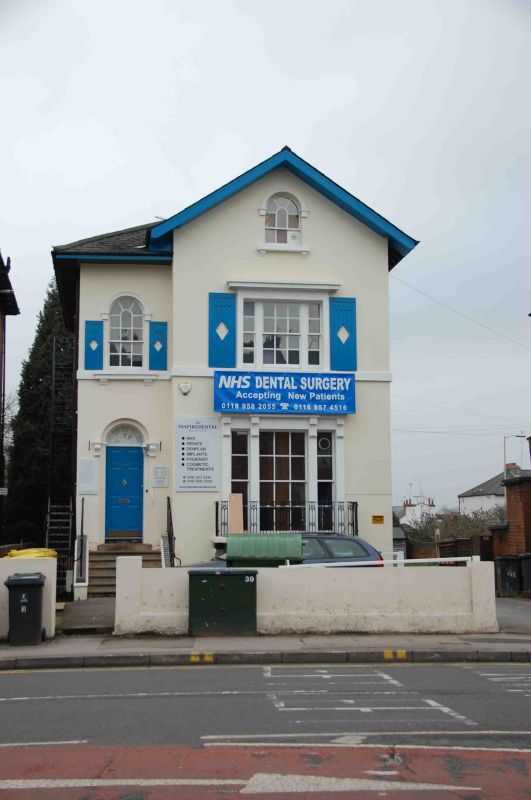
House, built in the 1850s or early 1860s, now a dental surgery.
MATERIALS AND PLAN: the building is rendered, with stone or stucco window and door surrounds, timber bargeboards, iron railings to the ground-floor window and a roof covering of slate. The building is of two-and-a-half storeys plus basement.
EXTERIOR: the entrance front has two bays onto Oxford Road. The eastern bay is larger, and projects forward of the smaller, western bay. A plat band runs across the principal elevation at first-floor cill height. The roof of the larger western bay is pitched with barge boards on the southern gable, while the roof of the eastern bay is hipped.
On the raised ground floor of the larger, eastern bay is a tripartite window with a pedimented cornice (the pediment is currently concealed by signage) and a decorative wrought and cast iron balcony supported on a bracketed stone base. Within this elaborate frame is a six-over-six sash window flanked by two-over-two sashes. On the first floor is a smaller and less elaborate tripartite window with cornice, comprising a six-over-six sash flanked by two-over-two sashes, with faux timber shutters. There is a round-arched window opening to the attic floor with a bracketed cill and hood mould, containing a uPVC casement window.
The main entrance is on the raised ground floor of the smaller, western bay. It comprises a six-panelled door under a sunburst fanlight, set within a round-arched, bracketed recess, accessed via a flight of stone steps with iron handrails. On the first floor is a round-arched sash window with bracket cill and hood mould, with faux timber shutters.
The two side elevations are rendered and blank aside from a single window each at first-floor level. On the western elevation, the window is a round-headed sash, while on the eastern elevation it is a modern, square-headed casement.
The rear elevation of the original house contains a single window at each floor, which appear to be sashes. To the western half of the rear elevation is a rendered, three-storey extension with a flat roof, containing modern casements at each level. There is a small, single-storey extension on the north-east corner of the building.
SUBSIDIARY FEATURES: to the Oxford Street boundary is a low, rendered wall, which may be contemporary to the house.
Until the C19, most of the land west of Reading town centre was open farmland crossed by two ancient routes passing through the town from London to the West Country. Today, the northern of these two roads is named Oxford Road, while the southern is named Castle Street/Castle Hill/Bath Road. Inns and some isolated dwellings probably existed on these roads before the C18. Fortifications were built throughout the area by Royalist forces garrisoned in the town during the Civil War with some of the earthworks surviving into the early C19.
From the early C18, development slowly began to spread westward along Castle Hill/Bath Road and Oxford Road. John Rocque’s Map of Berkshire (1761) depicts ribbon development along Castle Hill/Bath Road extending as far as the junction with Tilehurst Road, and individual houses within grounds along Oxford Road about as far as the present-day location of Russell Street. More comprehensive development of the area began in the early C19 and progressed gradually over the next 100 years. Development spread further along Castle Street/Castle Hill, with some of the earlier buildings depicted on Rocque’s map seemingly replaced. North-south link roads also were laid out across the market gardens that previously existed between Oxford Road and Bath Road. Terraced housing was erected in considerable quantities during the first half of the century to cater for a variety of social groups.
124 Oxford Road was built during the 1850s or early 1860s, during the westward expansion of Reading’s inner suburbs along Oxford Road. The Italianate villa incorporating a traditional pitched gable was originally named Oxford Villa and is labelled as such on the 1879 OS town plan of Reading. The first written reference to the building that has been identified is a newspaper notice of 1861 reporting the death of the owner, John Mattingly (Reading Mercury, 6 April 1861, p5).
By the early C20, the building was being let as apartments (Reading Observer, 16 November 1907, p4). Sometime between 1907 and 1950 the basement and ground floor of the building were converted to use as a dental practice, with a single flat on the first and second floors. The rear (north) extension was added in two phases, with the basement and ground floor being added in around 1961 and the first floor added or possibly rebuilt in around 1988. During the later C20, the basement was converted into a single flat while the upper floors were unified as a dental surgery. In 2011, the basement flat was incorporated into the dental surgery. Various internal changes were made to reconnect the basement to the rest of the building, along with other remodelling works on the upper floors involving the removal of non-original partitions. The building currently (2023) remains in use as a dental surgery.
The building’s front and rear gardens have been converted to use as car parks. The rendered boundary wall on Oxford Road may be contemporary to the construction of the building.
124 Oxford Road is listed at Grade II for the following principal reasons:
Architectural interest:
* as a mid-C19 building which contributes to the character of an architecturally varied historic streetscape.
Group value:
* the building is in close proximity to a large number of listed buildings and forms part of a strong historic grouping.
External links are from the relevant listing authority and, where applicable, Wikidata. Wikidata IDs may be related buildings as well as this specific building. If you want to add or update a link, you will need to do so by editing the Wikidata entry.


Other nearby listed buildings