Latitude: 51.4418 / 51°26'30"N
Longitude: -2.8534 / 2°51'12"W
OS Eastings: 340780
OS Northings: 171770
OS Grid: ST407717
Mapcode National: GBR JC.NJYP
Mapcode Global: VH7C7.H1C1
Plus Code: 9C3VC4RW+PJ
Entry Name: St Edith's Orphanage
Listing Date: 28 January 1975
Grade: II
Source: Historic England
Source ID: 1320722
English Heritage Legacy ID: 33049
ID on this website: 101320722
Location: Clevedon, North Somerset, BS21
County: North Somerset
Civil Parish: Clevedon
Built-Up Area: Clevedon
Traditional County: Somerset
Lieutenancy Area (Ceremonial County): Somerset
Tagged with: Architectural structure
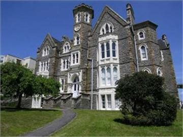
DIAL HILL ROAD l. 5121 (North East Side) St Edith's Orphanage ST 4071 1/143 28,1.75. II 2. Large late Victorian Gothic mansion on a prominent site overlooking Clevedon Bay. 4 storeys. Grey rubble walls with freestone dressings. Modern pantile roofs. Tall stone stacks with crenellated tops. The main front is asymmetrical with gabled wings coming forward to left and right. Small gable and polygonal turret with crenellated parapet rise above roof level in centre. Gables have cornices, parapets and flanking finials. Stringcourses. Small wheel window towards top of turret. 4 windows. Canted bays to lower storeys of gabled wings. Gothic pointed windows in various styles grouped in 2, 3 and 4-lights. Most windows have cusps, eared spandrels, hoodmoulds and sashes with plate-glass. Entrance under polygonal turret up a double flight of steps with balustraded parapet. Large pointed arch to doorway with nailhead detail in mouldings. Spandrels with shields, rectangular dripmould and corner shafts with outsize foliage capitals.
Listing NGR: ST4078071770
External links are from the relevant listing authority and, where applicable, Wikidata. Wikidata IDs may be related buildings as well as this specific building. If you want to add or update a link, you will need to do so by editing the Wikidata entry.


Other nearby listed buildings