Latitude: 54.1271 / 54°7'37"N
Longitude: -2.7689 / 2°46'8"W
OS Eastings: 349847
OS Northings: 470412
OS Grid: SD498704
Mapcode National: GBR 9N3Q.B9
Mapcode Global: WH83V.FJPF
Plus Code: 9C6V46GJ+RC
Entry Name: 10, North Road
Listing Date: 3 May 1949
Grade: II
Source: Historic England
Source ID: 1317967
English Heritage Legacy ID: 181833
ID on this website: 101317967
Location: Carnforth, Lancaster, Lancashire, LA5
County: Lancashire
District: Lancaster
Civil Parish: Carnforth
Built-Up Area: Carnforth
Traditional County: Lancashire
Lieutenancy Area (Ceremonial County): Lancashire
Church of England Parish: Carnforth Christ Church
Church of England Diocese: Blackburn
Tagged with: Building
SD 47 SE CARNFORTH NORTH ROAD
3/67 No. 10 3. 5. 1949
II
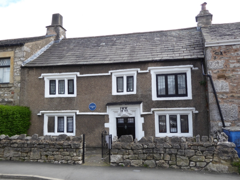
House, '1688 IWW' on lintel. Pebbledashed with slate roof. 2-unit central entry plan with end stacks. 2 storeys, 3 bays. Rebated and chamfered mullioned windows with a continuous drip on ground and 1st floor rising over each opening. 3-light windows on ground floor, the left-hand one having one light blocked. On the 1st floor one of 3 lights to the left, one of 2 lights in the centre, and a former 3-light window to the right with mullions removed and sill lowered. Moulding of door jambs continues around shaped lintel. Door has raised and fielded panels, the upper 2 being glazed.
Listing NGR: SD4984770412
External links are from the relevant listing authority and, where applicable, Wikidata. Wikidata IDs may be related buildings as well as this specific building. If you want to add or update a link, you will need to do so by editing the Wikidata entry.


Other nearby listed buildings