Latitude: 54.1629 / 54°9'46"N
Longitude: -1.5933 / 1°35'35"W
OS Eastings: 426651
OS Northings: 474202
OS Grid: SE266742
Mapcode National: GBR KN99.VG
Mapcode Global: WHC7M.HMHH
Plus Code: 9C6W5C74+5M
Entry Name: Azerley Tower
Listing Date: 11 June 1986
Grade: II
Source: Historic England
Source ID: 1315669
English Heritage Legacy ID: 331018
ID on this website: 101315669
Location: Azerley, North Yorkshire, HG4
County: North Yorkshire
District: Harrogate
Civil Parish: Azerley
Traditional County: Yorkshire
Lieutenancy Area (Ceremonial County): North Yorkshire
Tagged with: Tower Observation tower Folly tower
SE 27 SE AZERLEY EIGHT ACRE LANE (north side, off)
5/16 Azerley Tower
- II
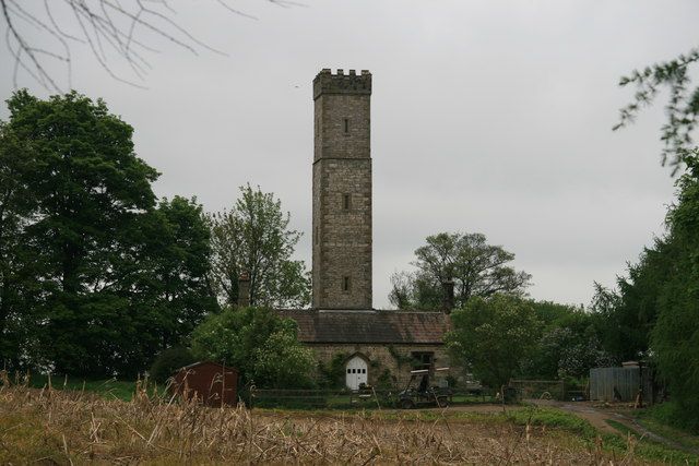
Folly and look-out tower. 1839, for Robert Crompton of Azerley Chase. Coursed cobbles and limestone rubble, gritstone dressings and quoins; stone slate roof. Single-storey 3-bay cottage, T-shaped in plan with a 2-stage tower approximately 20 metres high built in the centre of the south side, and projecting 2-bay service wing to the north. South facade: central arched double door with quoined jambs and Gothick arch with hood-mould flanked by cross-windows with quoined surrounds and hood-moulds. Stone gutter brackets, eaves band, raised verges, end corniced stacks. Tower: square in section with narrow staircase windows on each side. Moulded band at first stage and below embattled parapet. Rear: C20 porch and door, C19 and C20 windows. Interior not inspected. The tower is said to have been built by Robert Crompton as a gamekeeper's house and watch tower to trace the movement of game birds and poachers.
Listing NGR: SE2956070331
External links are from the relevant listing authority and, where applicable, Wikidata. Wikidata IDs may be related buildings as well as this specific building. If you want to add or update a link, you will need to do so by editing the Wikidata entry.


Other nearby listed buildings