Latitude: 53.5434 / 53°32'36"N
Longitude: -1.3118 / 1°18'42"W
OS Eastings: 445702
OS Northings: 405420
OS Grid: SE457054
Mapcode National: GBR MW8G.SH
Mapcode Global: WHDCZ.T6JC
Plus Code: 9C5WGMVQ+97
Entry Name: Hall Farmhouse
Listing Date: 29 January 1985
Grade: II
Source: Historic England
Source ID: 1315022
English Heritage Legacy ID: 333667
ID on this website: 101315022
Location: Thurnscoe, Barnsley, South Yorkshire, S63
County: Barnsley
Electoral Ward/Division: Dearne North
Parish: Non Civil Parish
Built-Up Area: Thurnscoe
Traditional County: Yorkshire
Lieutenancy Area (Ceremonial County): South Yorkshire
Church of England Parish: Thurnscoe St Helen
Church of England Diocese: Sheffield
Tagged with: Farmhouse
SE40NE DEARNE SHEPHERD LANE (east side), Thurnscoe
4/39 Hall Farmhouse
29.1.85 II
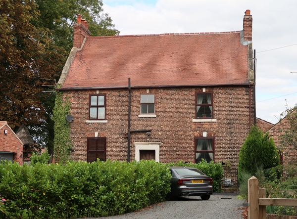
Farmhouse. Late C18 or early C19. Brick in English Garden Wall bond, renewed tile roof with stone slates to rear, renewed brick stacks. 2 storeys with attic, 3 windows to 1st floor. Brick plinth. Panelled door to left of centre in plain ashlar limestone surround with pulvinated frieze and cornice. Flanking 4-pane sashes with projecting stone sills and gauged-brick flat arches with limestone keystones. 3 similar windows to 1st floor, window over door narrower. Cogged eaves. Stone kneelers and ashlar gable copings. End stacks. Rear: tall stair-window. Interior: stone staircase. Lean-to extension to right return not of special interest.
Listing NGR: SE4570205420
External links are from the relevant listing authority and, where applicable, Wikidata. Wikidata IDs may be related buildings as well as this specific building. If you want to add or update a link, you will need to do so by editing the Wikidata entry.


Other nearby listed buildings