Latitude: 53.5192 / 53°31'9"N
Longitude: -1.1181 / 1°7'5"W
OS Eastings: 458572
OS Northings: 402868
OS Grid: SE585028
Mapcode National: GBR NWMR.R5
Mapcode Global: WHDD2.SSSY
Plus Code: 9C5WGV9J+MQ
Entry Name: 48 and 50, Bennetthorpe
Listing Date: 23 April 1981
Last Amended: 5 September 1988
Grade: II
Source: Historic England
Source ID: 1314874
English Heritage Legacy ID: 335001
ID on this website: 101314874
Location: Belle Vue, Doncaster, South Yorkshire, DN2
County: Doncaster
Electoral Ward/Division: Town
Parish: Non Civil Parish
Built-Up Area: Doncaster
Traditional County: Yorkshire
Lieutenancy Area (Ceremonial County): South Yorkshire
Church of England Parish: Doncaster Holy Trinity (No church)
Church of England Diocese: Sheffield
Tagged with: Building
TOWN OF DONCASTER BENNETTHORPE SE 50 SE (south side)
3/14 No 48 and 50 Bennetthorpe (formerly listed with 44, 23.4.81 46, 52 and 54 as 44-54 (even))
GV II
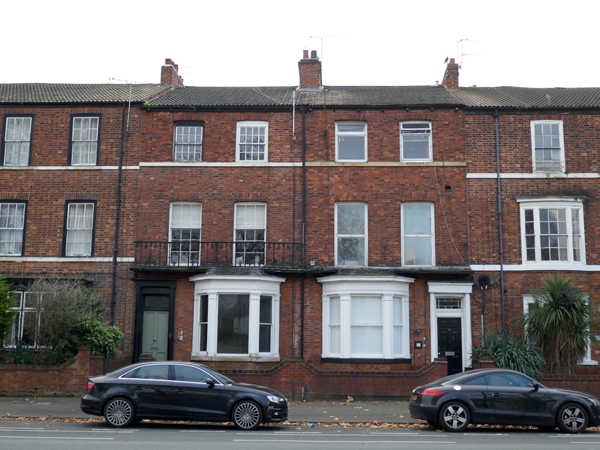
Pair of houses. Early C19 with later alterations. Red brick with brick and stone dressings and concrete tile roofs. Three storeys, each house 2 bays. Each house has doorcase of engaged columns with moulded cornice to outer bay, No 48 to right has C20 6-panelled door and original margin glazed overlight, No 50 has 4-panel door and plain overlight. To inner bays each house has a canted bay window with plate glass sashes in pilastered stone surrounds with moulded cornice. Above continuous bracketed first-floor balcony, No 48 with railings now missing. Railings to No 50 have acanthus leaf pendents and finials between plain bars. Each house with 2 full-height first-floor sashes, those to No 48 of 2 equal panes and those to No 50 of 15 panes unequally hung. Above continuous second floor stone sill band, pair of 12-pane sashes to No 50 and two C20 windows in original openings to No 48. All windows beneath cambered brick arches. Bracketed eaves. Central brick ridge stack.
Listing NGR: SE5857202868
External links are from the relevant listing authority and, where applicable, Wikidata. Wikidata IDs may be related buildings as well as this specific building. If you want to add or update a link, you will need to do so by editing the Wikidata entry.


Other nearby listed buildings