Latitude: 52.5537 / 52°33'13"N
Longitude: -1.0885 / 1°5'18"W
OS Eastings: 461895
OS Northings: 295483
OS Grid: SP618954
Mapcode National: GBR 9PT.TWP
Mapcode Global: VHCT2.22WP
Plus Code: 9C4WHW36+FH
Entry Name: School
Listing Date: 14 October 1986
Grade: II
Source: Historic England
Source ID: 1307566
English Heritage Legacy ID: 188911
ID on this website: 101307566
Location: Kilby, Blaby, Leicestershire, LE18
County: Leicestershire
District: Blaby
Civil Parish: Kilby
Traditional County: Leicestershire
Lieutenancy Area (Ceremonial County): Leicestershire
Church of England Parish: Kilby St Mary Magdalene
Church of England Diocese: Leicester
Tagged with: School building
KILBY SP69 NW MAIN STREET (North Side)
2/41 School
GV II
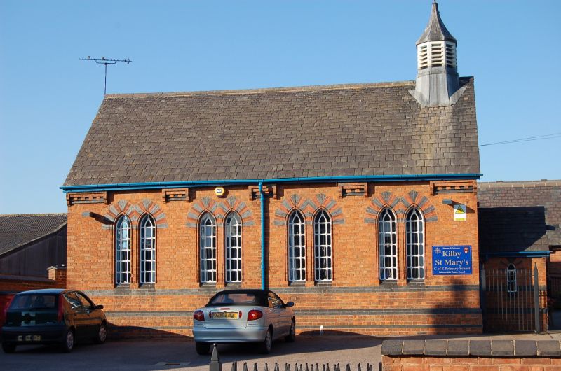
School. 1875. Brick with Swithland slate roof. 4 bays with paired lancet windows with red and blue brick heads and ornate glazing. Red and blue brick eaves cornices interrupted by the window arches. Blue brick sill band and plinth. Small gabled porch on eastern gable. Polygonal leaded cupola above with weather vane.
Listing NGR: SP6189595483
External links are from the relevant listing authority and, where applicable, Wikidata. Wikidata IDs may be related buildings as well as this specific building. If you want to add or update a link, you will need to do so by editing the Wikidata entry.


Other nearby listed buildings