Latitude: 54.8381 / 54°50'17"N
Longitude: -2.4678 / 2°28'4"W
OS Eastings: 370049
OS Northings: 549353
OS Grid: NY700493
Mapcode National: GBR CD6H.JG
Mapcode Global: WH91N.2N3D
Plus Code: 9C6VRGQJ+6V
Entry Name: Range of Farmbuildings 10 Metres North East of Underbank Farmhouse
Listing Date: 23 August 1985
Grade: II
Source: Historic England
Source ID: 1303309
English Heritage Legacy ID: 240269
ID on this website: 101303309
Location: Northumberland, CA9
County: Northumberland
Civil Parish: Knaresdale with Kirkhaugh
Traditional County: Northumberland
Lieutenancy Area (Ceremonial County): Northumberland
Church of England Parish: Alston Moor
Church of England Diocese: Newcastle
Tagged with: Agricultural structure
NY 74 NW KNARESDALE WITH KIRKHAUGH KIRKHAUGH
19/150 Range of farmbuildings 10 metres north-east of Underbank Farmhouse II
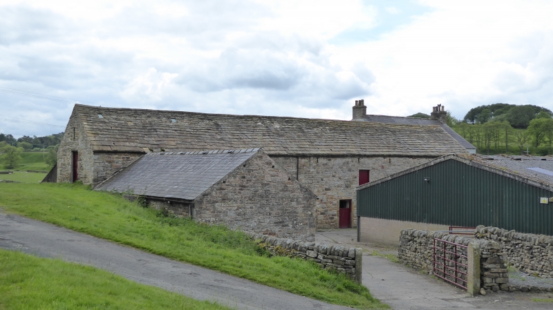
Bastle houses, late C16 or early C17, remodelled as farm building Cl9. Rubble, with massive roughly-shaped quoins and stone dressings, stone slate roofs. Elevation to farmyard in 3 parts. Left section is barn, probably C19; large cart entrance with timber lintel. Central section is earlier bastle, 2 storeys, 4 irregular bays, largely rebuilt; 2 boarded doors, the left with jambs and re-set lintel with double roll moulding (lintel inscribed TB? 1691) right with chamfered jambs and re-set roll-moulded lintel. To left small 4-pane window with re-set window head over inscribed GT. SEP : XX. Right section is second bastle, 2 storeys, 2 bays. Boarded door with 2-pane overlight in tall chamfered surround; small boarded window to right and chamfered window with old iron bar above. Right return has external stair to inserted door, blocked chamfered attic loop above and to left. Rear elevation; left section, second bastle, has small ground floor loop, 1st floor blocked chamfered window and 2-light chamfered mullioned window with diamond glazing; blocked chamfered attic window above; central section with 2 chamfered loops to ground floor, wall above obscured by ivy; C20 barn hides right section.
Interior much altered.
Listing NGR: NY7004949353
External links are from the relevant listing authority and, where applicable, Wikidata. Wikidata IDs may be related buildings as well as this specific building. If you want to add or update a link, you will need to do so by editing the Wikidata entry.


Other nearby listed buildings