Latitude: 52.6767 / 52°40'36"N
Longitude: -2.1734 / 2°10'24"W
OS Eastings: 388374
OS Northings: 308789
OS Grid: SJ883087
Mapcode National: GBR 18D.3BV
Mapcode Global: WHBFC.LZ8C
Plus Code: 9C4VMRGG+MM
Entry Name: 2, Sandy Lane
Listing Date: 28 March 1985
Grade: II
Source: Historic England
Source ID: 1295067
English Heritage Legacy ID: 271392
ID on this website: 101295067
Location: Brewood, South Staffordshire, ST19
County: Staffordshire
District: South Staffordshire
Civil Parish: Brewood and Coven
Built-Up Area: Brewood
Traditional County: Staffordshire
Lieutenancy Area (Ceremonial County): Staffordshire
Church of England Parish: Brewood St Mary and St Chad
Church of England Diocese: Lichfield
Tagged with: Building
BREWOOD C.P. SANDY LANE SJ 8808-8908 (South West side)
13/83 No. 2
- II
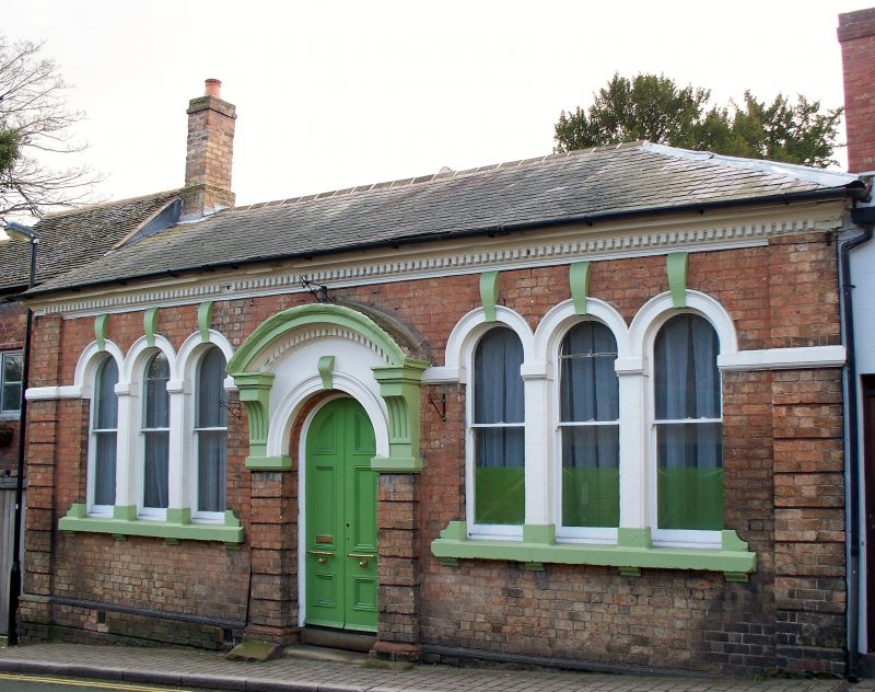
Perhaps former school or library. Mid C19. Red brick with stone dentilled and moulded cornice; slate roof, hipped to right; brick end stacks. Italianate. 1 storey; 2 tripartite round headed windows with bracketed sills and plaster key blocks and surrounds continued as. bands to left and right; corner pilaster strips, plain above the band with channelled rustication below; plate glass sashes; central round headed, 6 panelled door with key block, flanked by pilaster strips with channelled rustication and fluted brackets supporting a segmental open base pediment. Similar, but more ornate style in Codsall railway station (qv).
Listing NGR: SJ8837408789
External links are from the relevant listing authority and, where applicable, Wikidata. Wikidata IDs may be related buildings as well as this specific building. If you want to add or update a link, you will need to do so by editing the Wikidata entry.


Other nearby listed buildings