Latitude: 52.4933 / 52°29'35"N
Longitude: -1.2739 / 1°16'25"W
OS Eastings: 449397
OS Northings: 288623
OS Grid: SP493886
Mapcode National: GBR 7MP.NRJ
Mapcode Global: VHCT4.VLXH
Plus Code: 9C4WFPVG+8F
Entry Name: Dairy Farmhouse
Listing Date: 30 September 1993
Grade: II
Source: Historic England
Source ID: 1292802
English Heritage Legacy ID: 392521
ID on this website: 101292802
Location: Claybrooke Magna, Harborough, Leicestershire, LE17
County: Leicestershire
District: Harborough
Civil Parish: Claybrooke Magna
Built-Up Area: Claybrooke Magna
Traditional County: Leicestershire
Lieutenancy Area (Ceremonial County): Leicestershire
Church of England Parish: Claybrooke St Peter
Church of England Diocese: Leicester
Tagged with: Farmhouse
CLAYBROOKE MAGNA THE VINEYARD SP48NE 1323-0 2/32 (North side) Dairy Farmhouse II
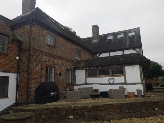
House. C17 with front block of early C18, but containing C15 survivals. Timber-framed to rear with front block of red and blue brick chequer; plain tiled roof. Two storeys with dentilled brick band and brick cornice. Roof hipped to front with gabled wing to rear. Two gabled dormers and brick ridge stacks on rear wing. Irregular three window front, wide casements with gauged flat-arched surrounds on ground floor. Panelled door, probably C19, in pilastered doorcase with flat hood over. West elevation, two bays of C18 date in brick chequer, continued by C19 red brickwork to left. Gable to right on north side with C17 timber frame exposed below gable and on the east return front of its wing. Lean-to addition on angle and C19 11/2 storey extension to east. (The Buildings of England: Pevsner N, Williamson E, Brandwood G: Leicestershire and Rutland: London: 1984-: 132).
Listing NGR: SP4939788623
External links are from the relevant listing authority and, where applicable, Wikidata. Wikidata IDs may be related buildings as well as this specific building. If you want to add or update a link, you will need to do so by editing the Wikidata entry.


Other nearby listed buildings