Latitude: 52.2967 / 52°17'47"N
Longitude: -0.3891 / 0°23'20"W
OS Eastings: 509951
OS Northings: 267724
OS Grid: TL099677
Mapcode National: GBR H1G.Y6C
Mapcode Global: VHFPJ.6JNR
Plus Code: 9C4X7JW6+M9
Entry Name: Kimbolton House
Listing Date: 24 October 1951
Grade: II
Source: Historic England
Source ID: 1290431
English Heritage Legacy ID: 395098
ID on this website: 101290431
Location: Kimbolton, Huntingdonshire, Cambridgeshire, PE28
County: Cambridgeshire
District: Huntingdonshire
Civil Parish: Kimbolton
Built-Up Area: Kimbolton
Traditional County: Huntingdonshire
Lieutenancy Area (Ceremonial County): Cambridgeshire
Church of England Parish: Kimbolton St Andrew
Church of England Diocese: Ely
Tagged with: House
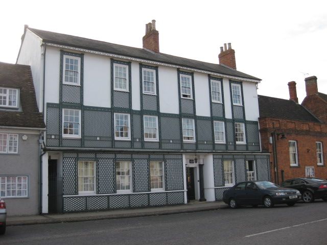
KIMBOLTON HIGH STREET TL 095675 (SOUTH-WEST SIDE) 6/34 NO. 9 24.10.51 (KIMBOLTON HOUSE) GV II Originally two separate C17 buildings with a central passage way incorporated into early C19 inn of two storeys with an additional range to south-west, 'The Sun' tap room. In mid C19 street range raised to three storeys and the tap room became the service wing to the house. A billiard room was added to north-west of the street range in the late C19. Brick and timber-frame rendered. Street elevation decorated by painted wooden trellis, divided into panels and forming surrounding frames to upper windows. Low pitched slate roof with deep boarded eaves with pierced pelmet and paired modillions. Side stacks. Ranges of six hung sash windows in moulded wooden frames with glazing bars at first and second floor levels. Slightly projecting ground floor has five similar windows. Door to right of centre with six raised and fielded panels in architraved doorcase with two attached Doric columns. Rear elevation to main range has six hung sash windows in round headed arches. The former Sun Inn forms rear service wing to south-west. Two storeyed, painted brick with low pitched slate roof, end stack to south-west. Three original first floor hung sash windows with glazing bars. Interior has C19 chimney pieces, doors and staircase. RCHM (Hunts) p175.
Listing NGR: TL0995167724
External links are from the relevant listing authority and, where applicable, Wikidata. Wikidata IDs may be related buildings as well as this specific building. If you want to add or update a link, you will need to do so by editing the Wikidata entry.


Other nearby listed buildings