Latitude: 53.6607 / 53°39'38"N
Longitude: -1.3035 / 1°18'12"W
OS Eastings: 446122
OS Northings: 418471
OS Grid: SE461184
Mapcode National: GBR MVB3.LG
Mapcode Global: WHDCD.Y7FZ
Plus Code: 9C5WMM6W+7H
Entry Name: Village Pump
Listing Date: 6 February 1969
Grade: II
Source: Historic England
Source ID: 1289685
English Heritage Legacy ID: 342493
ID on this website: 101289685
Location: East Hardwick, Wakefield, West Yorkshire, WF8
County: Wakefield
Civil Parish: East Hardwick
Traditional County: Yorkshire
Lieutenancy Area (Ceremonial County): West Yorkshire
Church of England Parish: East Hardwick St Stephen
Church of England Diocese: Leeds
Tagged with: Well
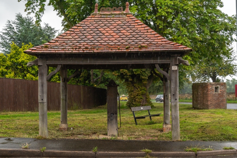
EAST HARDWICK DARRINGTON ROAD SE41NE (south side) 7/31 Village Pump 6.2.69 - II Village pump. Probably C19; restored, and shelter added, in early C20. Pump of lead and iron with wooden cladding; timber-framed shelter with red tiled roof. The pump is surrounded by wooden cladding, approx. 1 1/2 metres high, a drooping lead spout on the north side and an iron handle on the west side; and there is a sandstone slab beneath the spout, with rounded front and worn surface. The shelter is rectangular, and open-sided, with 4 timber corner posts and wavy braces to horizontal beams at the eaves, and a steeply-pitched hipped roof of fishscale tiles, swept over the eaves, and with cresting to the short ridge. The sides of the beams have incised decoration and lettering in Gothic script running round the whole from the north side:- "0 Ye Wells Bless Ye The Lord Praise Him And Magnify Him For Ever"
Listing NGR: SE4612218471
External links are from the relevant listing authority and, where applicable, Wikidata. Wikidata IDs may be related buildings as well as this specific building. If you want to add or update a link, you will need to do so by editing the Wikidata entry.


Other nearby listed buildings