Latitude: 50.7284 / 50°43'42"N
Longitude: -1.1622 / 1°9'43"W
OS Eastings: 459230
OS Northings: 92420
OS Grid: SZ592924
Mapcode National: GBR 9CN.709
Mapcode Global: FRA 87G5.129
Plus Code: 9C2WPRHQ+94
Entry Name: 7 Anglesea Street
Listing Date: 18 May 1972
Last Amended: 13 June 2024
Grade: II
Source: Historic England
Source ID: 1276283
English Heritage Legacy ID: 409898
ID on this website: 101276283
Location: Ryde, Isle of Wight, PO33
County: Isle of Wight
Civil Parish: Ryde
Built-Up Area: Ryde
Traditional County: Hampshire
Lieutenancy Area (Ceremonial County): Isle of Wight
Church of England Parish: Ryde
Church of England Diocese: Portsmouth
Tagged with: Building
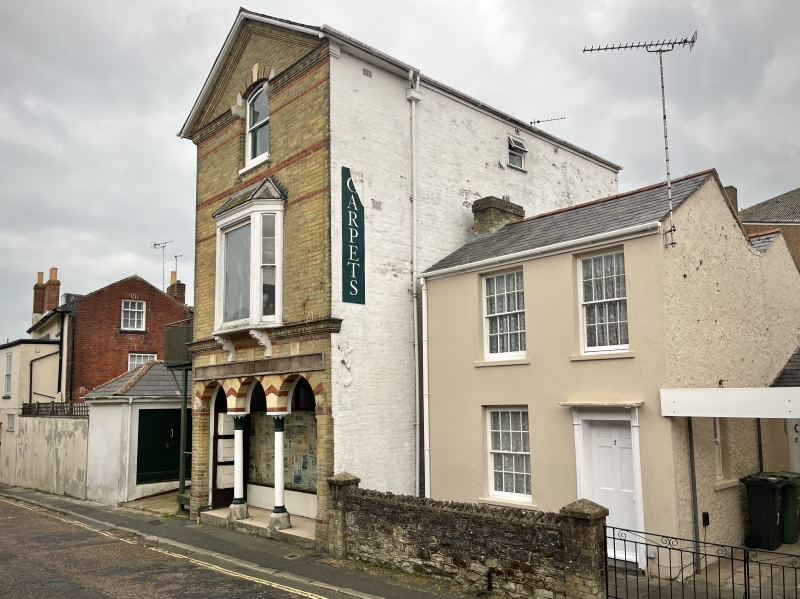
Small detached house (possibly once semi-detached), early C19.
Small detached house (possibly once semi-detached), early C19.
MATERIALS: stuccoed to the front, with rough-cast render to the side. The roof is covered in slate.
PLAN: the building faces north onto Anglesea Street. It is two bays wide and two storeys high with a double-pile plan; each pile has a pitched roof with gable ends to the east and west. The front roof has a brick ridge stack at its east end. Adjoining the west flank of the rear pile is a single-storey pitched roof range which seems to be shown on the 1843 Tithe map. The space between the side of the main house and the single-storey range has been roofed over as a car port.
EXTERIOR: the front elevation has three eight-over-eight sash windows: two to the first floor and one on the ground floor to the east of the door. The door has six fielded panels, a doorcase of narrow pilaster strips and simple bracketed projecting cornice.
The west side elevation has a small two-over-two sash window on the ground floor. The single-storey range has a doorway with a late-C20 glazed door.
Until the C19, Anglesea Street was undeveloped open land on the eastern fringe of the small farming community of Upper Ryde. The town developed rapidly in the first half of the C19 and Anglesea Street is shown laid out on the 1843 Tithe map linking the High Street to the west with the south end of George Street to the east. 7 Anglesea Street appears on the map, possibly as the west half of a semi-detached pair.
By 1863, the date of the first edition 25" Ordnance Survey map, the High Street had been developed on comparatively narrow plots whereas the wider George Street was lined with a number of detached and semi-detached villas with gardens. The north of Anglesea Street was largely occupied by the garden of Sudbury Villa (the house fronted George Street) but the south side had been developed with several small detached or semi-detached houses, including number 7 Anglesea Street.
The fishing village of ‘Le Ryde’ is recorded in the C14. By the late C18, what had been two medieval settlements: the farming community of Upper Ryde to the south, and the fishing and port community of Lower Ryde to the north by the coast, had been connected by the thoroughfare later known as Union Street.
During the early years of the C19 Ryde began to grow, culminating in the merger of Upper and Lower Ryde. From 1825 regular steam ferries began to operate between Ryde and Portsmouth. In 1829, the Ryde Improvement Act recognised Ryde as a town. A significant increase in the town’s population occurred during the first half of the C19, rising from around 1,000 in 1800 to 10,000 in the 1860s. Ryde developed as a seaside resort, encouraged by Queen Victoria’s presence on the island and the resulting boom in tourism. Its popularity continued into the C20, with the town acting as one of the main points of entry to the Isle of Wight.
7 Anglesea Street is listed at Grade II for the following principal reasons:
Architectural interest:
* as an early-C19 building, the fabric of which contributes to Ryde’s architectural heritage.
Historic interest:
* as part of the urban development of Ryde during the C19.
Group value:
* the building is in close proximity to a number of other listed buildings, contributing to a historic streetscape.
External links are from the relevant listing authority and, where applicable, Wikidata. Wikidata IDs may be related buildings as well as this specific building. If you want to add or update a link, you will need to do so by editing the Wikidata entry.


Other nearby listed buildings