Latitude: 53.3479 / 53°20'52"N
Longitude: -2.247 / 2°14'49"W
OS Eastings: 383656
OS Northings: 383470
OS Grid: SJ836834
Mapcode National: GBR DYRQ.BL
Mapcode Global: WHBB7.G37S
Plus Code: 9C5V8QX3+46
Entry Name: Methodist Chapel, Farm Fold
Listing Date: 6 July 1984
Grade: II
Source: Historic England
Source ID: 1274757
English Heritage Legacy ID: 414119
ID on this website: 101274757
Location: Styal Cross, Cheshire East, Cheshire, SK9
County: Cheshire East
Civil Parish: Styal
Traditional County: Cheshire
Lieutenancy Area (Ceremonial County): Cheshire
Church of England Parish: Wilmslow St Bartholomew
Church of England Diocese: Chester
Tagged with: Chapel
SJ 88 SW WILMSLOW FORMER U.D. ALTRINCHAM ROAD, OFF (South Side) Styal, Farm Fold
1/243 Methodist Chapel, Farm Fold.
GV II
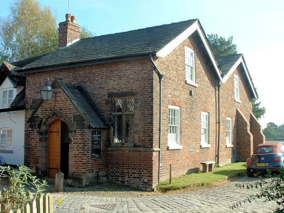
Formerly seed store, now Methodist Chapel, C18 with conversion to chapel c.1820 and new facade c.1860. Orange brick in English bond to front and English garden wall bond to sides and rear. Welsh slate roof and brick chimney. Rectangular plan of 2 parallel ridges. 1-storey, 3-bay west front is an added facade. Stone mullioned and transom windows flank projecting stone-coped gabled porch. This has 4-centred arched, chamfered stone doorcase under a label mould which contains a pair of studded, grained doors. South front has a regular pattern of 16-pane sashes on 2-storeys about a blocked central doorway. Interior: Very simple with long west gallery on a line of plain iron columns.
Listing NGR: SJ8365683470
External links are from the relevant listing authority and, where applicable, Wikidata. Wikidata IDs may be related buildings as well as this specific building. If you want to add or update a link, you will need to do so by editing the Wikidata entry.


Other nearby listed buildings