Latitude: 51.5861 / 51°35'9"N
Longitude: -2.1009 / 2°6'3"W
OS Eastings: 393107
OS Northings: 187477
OS Grid: ST931874
Mapcode National: GBR 2QZ.HNF
Mapcode Global: VH95S.JDQF
Plus Code: 9C3VHVPX+CM
Entry Name: 65 and 67, Gloucester Road
Listing Date: 1 July 1976
Grade: II
Source: Historic England
Source ID: 1269463
English Heritage Legacy ID: 460748
ID on this website: 101269463
Location: Malmesbury, Wiltshire, SN16
County: Wiltshire
Civil Parish: Malmesbury
Built-Up Area: Malmesbury
Traditional County: Wiltshire
Lieutenancy Area (Ceremonial County): Wiltshire
Church of England Parish: Malmesbury and Brokenborough
Church of England Diocese: Bristol
Tagged with: Building
MALMESBURY
ST9387 GLOUCESTER ROAD 758-1/2/86 (East side) 01/07/76 Nos.65 AND 67
GV II
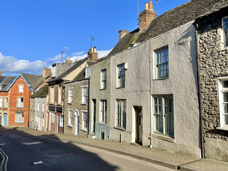
House, now divided into 2. Early C15, refronted and divided late C18. Rendered limestone rubble with brick ridge and left-hand axial stacks and stone slate roof. PLAN: 3-room plan with through-passage formerly backing onto hall on right (No.65) with former service end to left (No.67); C15 hall open to fine arch-braced ceiling but with little evidence of smoke blackening; the upper end of the hall was rebuilt and is now No.63 (qv). EXTERIOR: 2 storeys and attic; 3-window range. A parapeted front, near-symmetrical to No.65 with a central, recessed doorway with half-glazed door, recessed windows, paired 4/4-pane right-hand sashes and matching double left-hand casements, with 8/8-pane first-floor sashes, and a small dormer; No.67 has a left-hand doorway with 3-pane overlight and 6-panel door, the top pair glazed, paired 4/4-pane ground-floor sash and 8/8-pane first-floor sash. Rubble rear elevation has C18 brick rebuilt left-hand first-floor. INTERIOR: 5-bay roof with faint soot blackening extending across Nos 65 and 67, with chamfered, arch-braced collars, wind braces or their mortices to tenoned purlins, and a threaded ridge beam, the upper faces of the trusses facing to the right-hand end, with lath and plaster partitions; No.65 has ceiling beams with wide chamfers on first-floor and a C15 moulding in the left-hand bedroom, and similarly-moulded probably re-set ceiling beam in the ground-floor right-hand room; steps down to cellar cut into rock on line of former through-passage beside inserted stack; C18 stone fire surround with moulded sides and roundels. No.67 has a winder stair to the rear of a left-hand stack, projecting into No.69 (qv) to the left. HISTORICAL NOTE: a former hall house on the fringe of the town with a through-passage on the line of the stack, with inserted first-floor ceiling, axial stack and facade. The ridge and bracing are identical to that in the early C15 No.9 Oxford Street (qv).
Listing NGR: ST9311087473
External links are from the relevant listing authority and, where applicable, Wikidata. Wikidata IDs may be related buildings as well as this specific building. If you want to add or update a link, you will need to do so by editing the Wikidata entry.


Other nearby listed buildings