Latitude: 51.5841 / 51°35'2"N
Longitude: -2.0963 / 2°5'46"W
OS Eastings: 393426
OS Northings: 187256
OS Grid: ST934872
Mapcode National: GBR 2QZ.QTH
Mapcode Global: VH95S.MF4Y
Plus Code: 9C3VHWM3+MF
Entry Name: Tower House
Listing Date: 18 January 1949
Grade: II*
Source: Historic England
Source ID: 1269271
English Heritage Legacy ID: 460935
ID on this website: 101269271
Location: Malmesbury, Wiltshire, SN16
County: Wiltshire
Civil Parish: Malmesbury
Built-Up Area: Malmesbury
Traditional County: Wiltshire
Lieutenancy Area (Ceremonial County): Wiltshire
Church of England Parish: Malmesbury and Brokenborough
Church of England Diocese: Bristol
Tagged with: House
MALMESBURY
ST9387 OXFORD STREET 758-1/4/276 (East side) 18/01/49 Tower House
GV II*
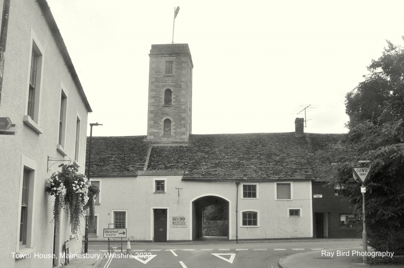
Medieval hall with later rear wing, attached to terrace of 4 houses, with inserted tower; one house since early C19, when refronted. Late C15 hall, with a mid C16 rear wing, terrace of four C18 houses; refronted and tower added 1834. MATERIALS: hall of limestone rubble, rear wing of re-used ashlar and carved work (a feature of post-Dissolution Malmesbury) and coursed, squared limestone; tower of rubble with dressings, rubble houses; all rendered to street elevations, with a stone slate roof and 3 ridge stacks. PLAN: open hall parallel to street with an E range at S end, square tower attached within S end of terrace of single-depth houses, with a rear wing to the N end. EXTERIOR: 2 storeys; 7-window range, includes 5-storey; 1-window range tower. The hall has C19 openings with a cambered arch to left-hand C19 carriage arch, 2 ground and first-floor windows, that on the first-floor to the S a trefoil in a square head; the E range to the rear has ground-floor lunettes and stable doors, the E section largely original with a blocked 4-light hollow-moulded window and E doorway with chamfered head, and C19 9-pane windows beneath the eaves. The 3 N houses have a middle 1-window range and outer 2-window ranges, that to the right with 6/6-pane sashes and a right-hand 6/9-pane sash in the former doorway, the middle one with a left-hand round-arched doorway and 8/8-pane sashes, and the N one a left-hand doorway, 8/8-pane ground-floor sash and two first-floor sashes with 6/6-panes to left and 8/8-panes to right; three gables to rear elevation. The S house was converted to a tower has a doorway and small window above; the tower has quoins and dressings to round-arched windows to the lower floors, flat-headed to the top storey, with an ashlar parapet. INTERIOR: details include a 3- former 4-bay roof to the hall with collar trusses and chamfered arch braces forming continuous arches, wind braces to the lower 2 registers, and a diagonal through ridge beam; possible former screened passage beneath the tower; the E range has collared trusses with wind braces to the middle register; houses have C19 reeded architraves with plain stops. HISTORICAL NOTE: possibly part of an extensive courtyard
complex with the S range originally stables (Stirling). Town work house from C18 to 1834, when converted to stables. The N house formerly the Salutation Inn before 1803. The tower was built for an astronomical observatory by Richard Pryor. (Stirling D: Secular medieval buildings in Malmesbury, Wilts, 1150-1547: 1986-: 8; The Buildings of England: Pevsner N: Wiltshire: London: 1963-: 328).
Listing NGR: ST9344587258
External links are from the relevant listing authority and, where applicable, Wikidata. Wikidata IDs may be related buildings as well as this specific building. If you want to add or update a link, you will need to do so by editing the Wikidata entry.


Other nearby listed buildings