Latitude: 53.1069 / 53°6'24"N
Longitude: -2.0258 / 2°1'32"W
OS Eastings: 398372
OS Northings: 356632
OS Grid: SJ983566
Mapcode National: GBR 24P.BMW
Mapcode Global: WHBCH.V5JJ
Plus Code: 9C5V4X4F+QM
Entry Name: St Edwards Vicarage
Listing Date: 13 April 1951
Grade: II
Source: Historic England
Source ID: 1268610
English Heritage Legacy ID: 461615
ID on this website: 101268610
Location: Leek, Staffordshire Moorlands, Staffordshire, ST13
County: Staffordshire
District: Staffordshire Moorlands
Civil Parish: Leek
Built-Up Area: Leek
Traditional County: Staffordshire
Lieutenancy Area (Ceremonial County): Staffordshire
Church of England Parish: Leek St Edward the Confessor
Church of England Diocese: Lichfield
Tagged with: Clergy house
LEEK
SJ9856NW CHURCH STREET 611-1/4/40 (North side) 13/04/51 St Edward's Vicarage
GV II
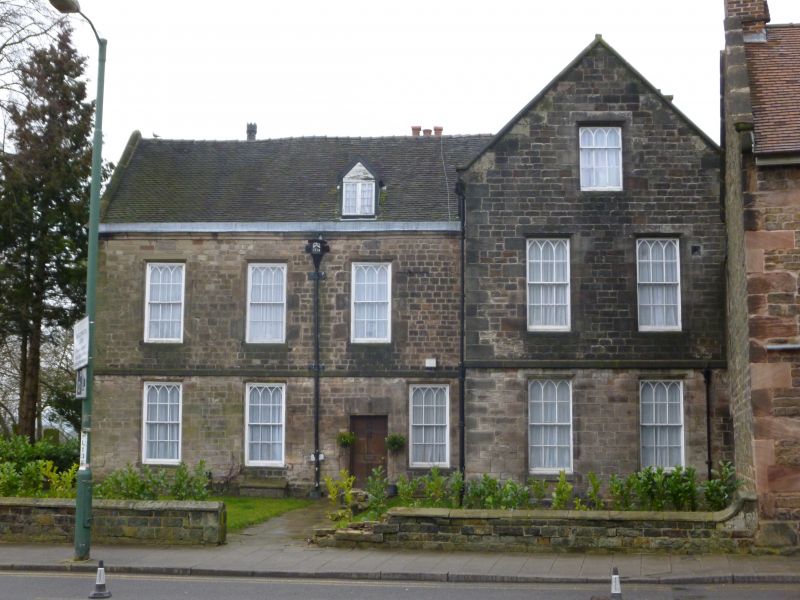
Vicarage. Dated 1714 on rainwater head. Well coursed and squared stone with plain-tiled roof. EXTERIOR: 2 storeys, 3-window range with additional advanced gabled wing to right, an early C19 addition. Doorway to right of centre in present main range (probably central in original building before the wing was added), giving access to wide entrance and stair hall. Windows throughout are 12-pane sashes with Gothick arched glazing in the upper panes, in moulded stone architraves, probably early C19. Advanced gabled wing to right forms a further 2-window range, with similar fenestration. Further wing added to rear late C19 or early C20, with large oriel window at first floor overlooking the churchyard. INTERIOR: wall-panelling and the staircase appear to relate to the original early C18 building.
Listing NGR: SJ9837256632
External links are from the relevant listing authority and, where applicable, Wikidata. Wikidata IDs may be related buildings as well as this specific building. If you want to add or update a link, you will need to do so by editing the Wikidata entry.


Other nearby listed buildings