Latitude: 51.5491 / 51°32'56"N
Longitude: -0.0741 / 0°4'26"W
OS Eastings: 533631
OS Northings: 185118
OS Grid: TQ336851
Mapcode National: GBR HD.3Z3
Mapcode Global: VHGQT.NBP8
Plus Code: 9C3XGWXG+M9
Entry Name: Colvestone Primary School
Listing Date: 4 February 1975
Grade: II
Source: Historic England
Source ID: 1265832
English Heritage Legacy ID: 423702
ID on this website: 101265832
Location: Dalston, Hackney, London, E8
County: London
District: Hackney
Electoral Ward/Division: Dalston
Parish: Non Civil Parish
Built-Up Area: Hackney
Traditional County: Middlesex
Lieutenancy Area (Ceremonial County): Greater London
Church of England Parish: St Mark Dalston
Church of England Diocese: London
Tagged with: School building
This list entry was subject to a Minor Amendment on 18 March 2025 to correct a typo in Name and Address and to reformat the text to current standards
TQ 3385
18/139
COLVESTONE CRESCENT E8 (North-West Side)
Colvestone Primary School
II
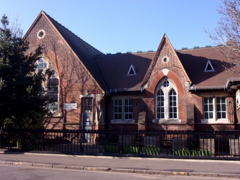
One-storey building with four main windows at either side of centre bay from which projects an open stone porch with pyramidal roof on short piers with carved capitals. 1862 by Knightley in Gothic style. High pitched tiled roofs with four gables fronting road, the wider outer gabled bays being ends of slightly projecting wings. Red brick with stone dressings. Sloped buttresses between bays. Paired or tripled cusped lancet windows with round plate windows above, all under pointed brick arches, and all varying slightly. Smaller, plainer windows between.
Listing NGR: TQ3363185118
External links are from the relevant listing authority and, where applicable, Wikidata. Wikidata IDs may be related buildings as well as this specific building. If you want to add or update a link, you will need to do so by editing the Wikidata entry.


Other nearby listed buildings