Latitude: 51.2092 / 51°12'33"N
Longitude: -1.478 / 1°28'40"W
OS Eastings: 436558
OS Northings: 145687
OS Grid: SU365456
Mapcode National: GBR 72R.53Z
Mapcode Global: VHC2S.BVHW
Plus Code: 9C3W6G5C+MQ
Entry Name: Priory Lodge
Listing Date: 24 February 1950
Last Amended: 3 October 1983
Grade: II
Source: Historic England
Source ID: 1264538
English Heritage Legacy ID: 354792
ID on this website: 101264538
Location: Andover, Test Valley, Hampshire, SP10
County: Hampshire
District: Test Valley
Civil Parish: Andover
Built-Up Area: Andover
Traditional County: Hampshire
Lieutenancy Area (Ceremonial County): Hampshire
Church of England Parish: Andover St Mary
Church of England Diocese: Winchester
Tagged with: Gatehouse
In the entry for
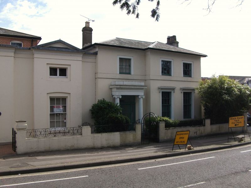
24/83 ANDOVER NEWBURY STREET No 6 (Priory Lodge) and No 6A [Formerly listed as No 2 (Priory Lodge including Stables)] The entry shall be amended to read No 4 and 6 (Priory Lodge) and No 6A [Formerly listed as No 2 (Priory Lodge including Stables)] ----------------------------------------- SU 3645 NE ANDOVER NEWBURY STREET 4/83 No 6 (Priory Lodge) and 24.2.50 No 6A [Formerly listed as No 2 (Priory Lodge including Stables)] GV II Villa of severe classical treatment with an irregular front (north) of 2 storeys and basement, 1.1.2 windows. Low-pitched hipped slate roofing, with a wide soffit ending in a moulding above a plain fascia. Stucco walling; the east wing has a slightly- projecting centrepiece (containing the opening) with a plain cornice coping above a fascia, recessed plain architraves (with cambered head to the ground-floor), plinth; the main block projects slightly at the west side (of 2 windows), plain recessed architraves to the first floor, plain first floor cill band, cornices on brackets above recessed architraves to the tall ground floor windows, plinth with cambered arches to the basement openings (protected by cast-iron rails). Sashes in reveals. Ionic porch with 2 columns and pilasters, the wide opening having a fanlight and sidelights. At the west side is attached a wall between piers. The rear elevation is symmetrical, of 2 storeys, 3 windows, with first floor band, sashes to the first floor, French windows to the ground floor within a cast-iron trellis verandah of 6 openwork columns linked by arches. The roadside forecourt has a wall and pier in yellow brickwork at the east side, connected to the adjoining curtilage (No 8), there are the remains of high rear garden walling, with a surviving tall octagonal pier with Gothic detals (in stucco on brickwork). Curving interior staircase.
Listing NGR: SU3655945679
External links are from the relevant listing authority and, where applicable, Wikidata. Wikidata IDs may be related buildings as well as this specific building. If you want to add or update a link, you will need to do so by editing the Wikidata entry.


Other nearby listed buildings