Latitude: 53.9645 / 53°57'52"N
Longitude: -1.088 / 1°5'16"W
OS Eastings: 459928
OS Northings: 452427
OS Grid: SE599524
Mapcode National: GBR NQVL.7L
Mapcode Global: WHFC3.8M44
Plus Code: 9C5WXW76+QQ
Entry Name: 57, Bootham
Listing Date: 1 July 1968
Grade: II
Source: Historic England
Source ID: 1259438
English Heritage Legacy ID: 462900
ID on this website: 101259438
Location: York, North Yorkshire, YO30
County: York
Electoral Ward/Division: Guildhall
Parish: Non Civil Parish
Built-Up Area: York
Traditional County: Yorkshire
Lieutenancy Area (Ceremonial County): North Yorkshire
Church of England Parish: York St Olave with St Giles
Church of England Diocese: York
Tagged with: Building
YORK
SE5952SE BOOTHAM 1112-1/12/83 (North East side) 01/07/68 No.57
GV II
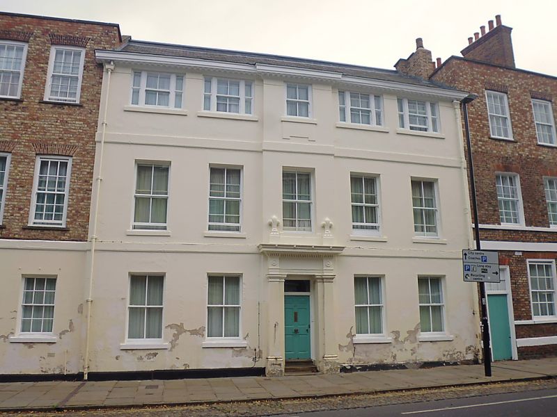
House, now part of school. Built shortly before 1759, altered c1830, and extended in C20. Stucco, with C20 addition in exposed brick. Slate roof. EXTERIOR: main part of house symmetrical, of 3 storeys and 5 bays. The central bay projects slightly, and the facade has 2 storey bands and a modillion gutter cornice. The windows are sashed. Except for the central bay the 2nd floor windows are tripartite. The doorcase has Tuscan pilasters, frieze blocks decorated with paterae, and a blocking course with fleur-de-lys finials. The door has 6 raised and fielded panels and there is a plain rectangular overlight. At the left there are 3 additional bays. On the ground floor they are stuccoed, but the upper storeys are C20 and of exposed brick. The windows are glazing bar sashes. On the ground floor the left-hand bay contains a boarded door to a passageway. The roof is hidden behind a parapet. Chimney to right. INTERIOR: not inspected. RCHM records original staircase with turned balusters, remaining fittings mostly mid C19. (An Inventory of the Historical Monuments in the City of York: RCHME: Outside the City Walls East of the Ouse: London: 1975-: 61).
Listing NGR: SE5996952435
External links are from the relevant listing authority and, where applicable, Wikidata. Wikidata IDs may be related buildings as well as this specific building. If you want to add or update a link, you will need to do so by editing the Wikidata entry.


Other nearby listed buildings