Latitude: 53.957 / 53°57'25"N
Longitude: -1.0886 / 1°5'18"W
OS Eastings: 459904
OS Northings: 451598
OS Grid: SE599515
Mapcode National: GBR NQVP.48
Mapcode Global: WHFC3.7SWV
Plus Code: 9C5WXW46+RH
Entry Name: 77 and 79, Micklegate
Listing Date: 14 June 1954
Grade: II
Source: Historic England
Source ID: 1257318
English Heritage Legacy ID: 464021
ID on this website: 101257318
Location: York, North Yorkshire, YO1
County: York
Electoral Ward/Division: Micklegate
Parish: Non Civil Parish
Built-Up Area: York
Traditional County: Yorkshire
Lieutenancy Area (Ceremonial County): North Yorkshire
Church of England Parish: Micklegate Holy Trinity
Church of England Diocese: York
Tagged with: Building
YORK
SE5951NE MICKLEGATE 1112-1/15/663 (South side) 14/06/54 Nos.77 AND 79
GV II
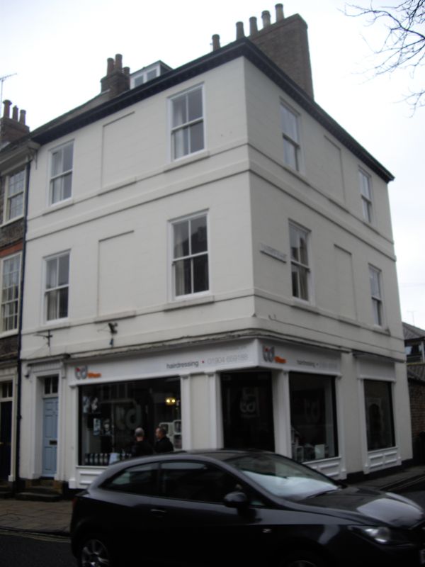
House. c1790, with mid C19 alteration and C20 shopfront. Front of stucco incised to resemble ashlar; rear of orange-red brick in stretcher bond; timber modillion cornice to hipped slate roof with scrolled corner brackets and brick stack. EXTERIOR: 3 storeys; 3 bays on both fronts of corner site. Shopfront on Micklegate, retaining earlier cornice, returns along Trinity Lane, with canted corner door, approached by shaped stone step. At left end of Micklegate front, upstairs door of 6 fielded panels beneath overlight, approached by stone steps, recessed in doorcase of narrow pilasters with triglyph frieze and moulded cornice hood on fluted console brackets. Upper floors of both fronts have blind openings in centre, flanked by 4-pane sashes, all beneath incised wedge lintels. Sill bands to both floors and raised second floor band return on Trinity Lane front. INTERIOR: ground floor: moulded cornice to entrance hall; round arch to staircase hall, on pilaster responds with fluted keyblock and imposts. Open string staircase with shaped treadends, slender turned balusters and ramped-up moulded handrail rises from ground floor to attic. Original fireplaces with cast-iron grates survive throughout. In attic, one plank and muntin partition wall survives. No.79 listed on 01/07/68. (City of York: RCHME: South-west of the Ouse: HMSO: 1972-: 81).
Listing NGR: SE5990451598
External links are from the relevant listing authority and, where applicable, Wikidata. Wikidata IDs may be related buildings as well as this specific building. If you want to add or update a link, you will need to do so by editing the Wikidata entry.


Other nearby listed buildings