Latitude: 53.2944 / 53°17'39"N
Longitude: -2.7289 / 2°43'44"W
OS Eastings: 351511
OS Northings: 377742
OS Grid: SJ515777
Mapcode National: GBR 9ZCB.ZR
Mapcode Global: WH87Y.1GS9
Plus Code: 9C5V77VC+QC
Entry Name: 52, Main Street
Listing Date: 6 April 1978
Last Amended: 6 December 1985
Grade: II
Source: Historic England
Source ID: 1253353
English Heritage Legacy ID: 436499
Also known as: The Gables, Frodsham
ID on this website: 101253353
Location: Frodsham, Cheshire West and Chester, Cheshire, WA6
County: Cheshire West and Chester
Civil Parish: Frodsham
Built-Up Area: Frodsham
Traditional County: Cheshire
Lieutenancy Area (Ceremonial County): Cheshire
Church of England Parish: Frodsham St Lawrence
Church of England Diocese: Chester
Tagged with: House
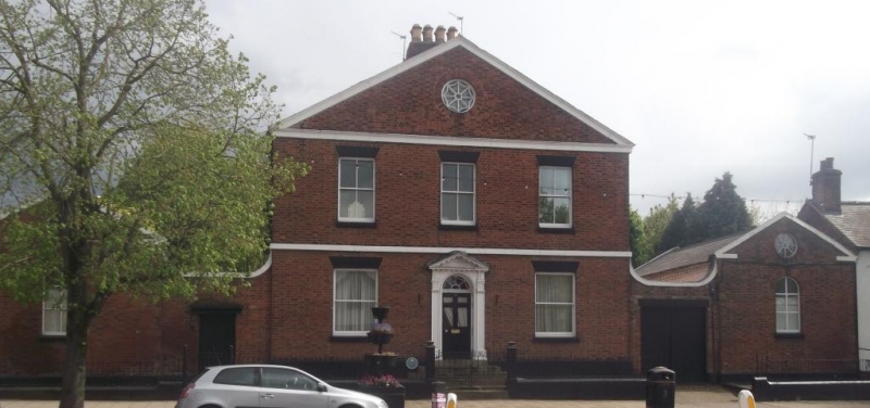
FRODSHAM C.P. MAIN STREET SJ 57 NW (South Side) 2/92 No. 52 (formerly listed as The Gables). 6/4/1978 GV II House with narrow yard to each side flanked by shed expressed as a pavilion. Mid C19. Flemish bond brown brick; grey slate roofs. House 2 storeys plus attic; 3 windows; open pediment gable to street. Painted sandstone plinth and 1st floor band. 6-panel door (upper 4 panels glazed) in pedimented case with panelled reveals and intrados to round arch containing looped radial-bar fanlight. Recessed sashes of 2 panes to lower storey and 4 panes to upper storey; round window to attic with radial bars and circumferential loops. Short wing wall to each side of house with stone coping curved up at each end. Shed to side of each yard has open pediment gable to street, a round-arched 6-pane fixed light and a radial-bar round window in gable. Interior not inspected. Apparently built as military premises (see item 93, adjoining).
Listing NGR: SJ5151177742
External links are from the relevant listing authority and, where applicable, Wikidata. Wikidata IDs may be related buildings as well as this specific building. If you want to add or update a link, you will need to do so by editing the Wikidata entry.


Other nearby listed buildings