Latitude: 53.1068 / 53°6'24"N
Longitude: -1.5621 / 1°33'43"W
OS Eastings: 429415
OS Northings: 356710
OS Grid: SK294567
Mapcode National: GBR 599.7WM
Mapcode Global: WHCDV.Z5BM
Plus Code: 9C5W4C4Q+P5
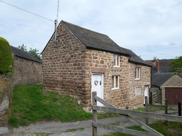
Entry Name: Building to the rear of 59 to 63, The Hill
Listing Date: 12 September 1990
Grade: II
Source: Historic England
Source ID: 1249111
English Heritage Legacy ID: 430954
ID on this website: 101249111
Location: Cromford, Derbyshire Dales, Derbyshire, DE4
County: Derbyshire
District: Derbyshire Dales
Civil Parish: Cromford
Built-Up Area: Cromford
Traditional County: Derbyshire
Lieutenancy Area (Ceremonial County): Derbyshire
Church of England Parish: Cromford St Mary
Church of England Diocese: Derby
Tagged with: Architectural structure
This list entry was subject to a Minor Amendment on 13 March 2025 to amend the name and address and reformat the text to current standards.
SK 29425671
1/140
CROMFORD
THE HILL
Building to the rear of 59 to 63
(Formerly listed as Structures 20 metres west of structure of uncertain function (ref 1/139), NORTH STREET)
GV
II
Two buildings, formerly barns. Late C18 or early C19 (marked on 1841 Tithe Map). Roughly coursed rubble; tiled roof to right-hand, corrugated iron to left, both under different roof levels and with vertical masonry joint between. Both with doorways, that to left with stone lintel, both with planked doors, and one first-floor opening. The right-hand building has a blocked three-light chamfered and rebated stone mullioned window to ground floor which looks inserted. No openings to end and rear walls.
Listing NGR: SK2941556710
External links are from the relevant listing authority and, where applicable, Wikidata. Wikidata IDs may be related buildings as well as this specific building. If you want to add or update a link, you will need to do so by editing the Wikidata entry.


Other nearby listed buildings