Latitude: 53.3594 / 53°21'33"N
Longitude: -1.4919 / 1°29'30"W
OS Eastings: 433912
OS Northings: 384849
OS Grid: SK339848
Mapcode National: GBR 9BT.MJ
Mapcode Global: WHDDP.1TVG
Plus Code: 9C5W9G55+Q6
Entry Name: The Edge
Listing Date: 17 January 1973
Grade: II
Source: Historic England
Source ID: 1246502
English Heritage Legacy ID: 455292
ID on this website: 101246502
Location: Nether Edge, Sheffield, South Yorkshire, S7
County: Sheffield
Electoral Ward/Division: Nether Edge and Sharrow
Parish: Non Civil Parish
Built-Up Area: Sheffield
Traditional County: Yorkshire
Lieutenancy Area (Ceremonial County): South Yorkshire
Church of England Parish: St Andrew, Psalter Lane
Church of England Diocese: Sheffield
Tagged with: Architectural structure House
This list entry was subject to a Minor Amendment on 12 August 2024 to correct a typo in the name and address and to reformat the text to current standards.
SK38SW
784-1/9/459
SHEFFIELD
LADYSMITH AVENUE (West side)
No.14
The Edge
II
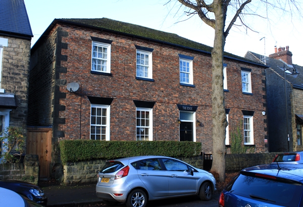
House, now flats. Late C18. Coursed rubble with brick front and stone dressings, with hipped artificial stone slate roof. Plinth and quoins. Two storeys; five window range of renewed 12 pane sashes with splayed lintels. Central C20 door and overlight flanked by two similar windows on each side. Right return has a single window to right on each floor. At the rear, canted bay containing stair.
INTERIOR not inspected.
Listing NGR: SK3391284849
External links are from the relevant listing authority and, where applicable, Wikidata. Wikidata IDs may be related buildings as well as this specific building. If you want to add or update a link, you will need to do so by editing the Wikidata entry.


Other nearby listed buildings