Latitude: 53.3992 / 53°23'57"N
Longitude: -1.4271 / 1°25'37"W
OS Eastings: 438191
OS Northings: 389306
OS Grid: SK381893
Mapcode National: GBR 9SC.M8
Mapcode Global: WHDDJ.1TQG
Plus Code: 9C5W9HXF+M5
Entry Name: Attercliffe Chapel
Listing Date: 28 June 1973
Grade: II
Source: Historic England
Source ID: 1246475
English Heritage Legacy ID: 455233
ID on this website: 101246475
Location: Attercliffe Hill Top, Sheffield, South Yorkshire, S9
County: Sheffield
Electoral Ward/Division: Darnall
Parish: Non Civil Parish
Built-Up Area: Sheffield
Traditional County: Yorkshire
Lieutenancy Area (Ceremonial County): South Yorkshire
Church of England Parish: Attercliffe and Darnall
Church of England Diocese: Sheffield
Tagged with: Church building
SHEFFIELD
SK38NE ATTERCLIFFE COMMON 784-1/6/35 (North West side) 28/06/73 Attercliffe Chapel
GV II
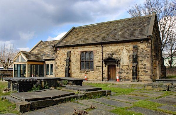
Also known as: Hilltop Chapel ATTERCLIFFE COMMON. Chapel. c1629. Probably built for the Bright family of Carbrook Hall. Remodelled c1770 and rebuilt and further remodelled 1909 by JD Webster. Restored 1991. Squared dressed stone with ashlar dressings and stone slate roof. Chamfered plinth, quoins, coped gables with kneelers. Single storey, single unit. East end has a 4-light transomed lancet with cusped heads, flanked by single buttresses. West end blank. South side has to right a shallow Tudor arched doorway with slate pediment on curved brackets, flanked to left by a monument bracket and to right by an obelisk tablet with cartouche. To left, a transomed triple lancet with round-headed lights under flat head. Beyond, on either side, single buttresses. North side has to left an oval headed doorway with similar pediment, and above it a datestone inscribed "1629 TA HB". To right, 2 transomed triple lancets similar to the south side. INTERIOR rendered and has late C18 strutted king post roof with double purlins. (The Buildings of England: Pevsner N: Yorkshire: The West Riding: London: 1967-: 469; Early C19 drawing, post-1817, in minister's keeping).
Listing NGR: SK3819189306
External links are from the relevant listing authority and, where applicable, Wikidata. Wikidata IDs may be related buildings as well as this specific building. If you want to add or update a link, you will need to do so by editing the Wikidata entry.


Other nearby listed buildings